|
||

|

|
|

|
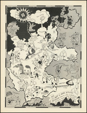
Mary Hall Atwood's A Complete Map of Los Angeles Area and Guide To Olympic Games, copyrighted in 1932, is a highly detailed and visually engaging pictorial map of Los Angeles. The map was designed to guide visitors and residents during the 1932 Summer Olympics, a significant event in the city's history. The map, published by the Union Oil Company, offers a comprehensive view of the city and its surroundings, with a focus on the venues and routes relevant to the Olympic Games.
The map is characterized by its intricate illustrations and extensive annotations, providing a wealth of information about the city and the Olympic events. It includes smaller maps illustrating various coastal and inland routes, such as the Coast Route from Los Angeles to Ensenada, the route from Los Angeles to Indio, and the route from Los Angeles to San Luis Obispo. The verso of the map features a calendar of events, short essays, and a map of the Olympic City, extending from the Riviera Country Club and USC and the Coliseum to City Hall.
The map provides detailed information about the locations of various Olympic events, including the opening and closing ceremonies, equestrian events, field hockey, football, gymnastics, lacrosse, marathon, track events, diving, swimming, fencing, boxing, weightlifting, wrestling, cycling, and rowing. It also indicates the locations of the Olympic Village, the home of visiting men athletes, and the University of Southern California, the home of visiting women athletes.
The map's creator, Mary Hall Atwood, was a skilled designer and illustrator, and her expertise is evident in the map's detailed depiction of the city and its landmarks. The map is not only a practical guide but also a historical document, capturing the geography and urban layout of Los Angeles during a pivotal moment in its history. As such, this map represents a significant contribution to the cartographic and historical understanding of Los Angeles in the early 20th century.

![[ First Map of Los Angeles / San Pedro Harbor ] Mouillage De San Pedro](https://storage.googleapis.com/raremaps/img/small/84665.jpg)