|
||

|

|
|

|
Stock# 88563
Description
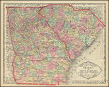
Attractive Antebellum map of South Carolina, colored by counties.
The map shows towns, railroads, roads, rivers, forts, post offices, etc.
There is an inset map of Charleston, hand-colored by wards.
The map includes a table of steamship routes.
Condition Description
Original hand-color. Toning at the edges.