|
||

|

|
|

|
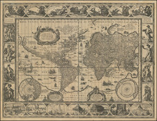
Fine, decorative, large, and unrecorded 19th-century double-hemisphere map of the world, including several decorative elements showing different civilizations and mountains of the world, as well as the constellations of the time.
The map is colored according to continents and shows the world in detail. The primitive dissection of Africa is somewhat visible, with the Orange River, Mozambique, and other regions are also shown.
Below the map are depictions of the peoples of the world. The Europeans are by far the most civilized looking, while the Americas are peopled with half-clothed men and women and drinking southerners. Oceania is shown as at the frontier of civilization, with meetings between Western and Aboriginal peoples. Below is a comparative chart of the mountains of the world, with Kunchinginga reported as the highest in Asia. Some of the night sky's major constellations are also shown.
Decorative world maps of this type, which were centered around a map but contained a plethora of other information as well, were popular in the late 19th century, particularly in France and Britain.
Rarity
We trace no mention of this map through OCLC or other sources.
![Eastern Hemisphere [with] Western Hemisphere](https://storage.googleapis.com/raremaps/img/small/92642.jpg)
![[From the Library of Captain Louis Freycinet] Carte Hydrographique Des Partes Connues De La Terre Dressee sur la Projection de Mercator, Poar C.LO. Gressier , Ingenieur Hydrographe de la Marine . . . 1835 (with extensive manuscript annotations)](https://storage.googleapis.com/raremaps/img/small/58604.jpg)
![[ Hand Drawn World Map On Polar Azimuthal Projection ]](https://storage.googleapis.com/raremaps/img/small/27497.jpg)