|
||

|

|
|

|
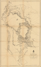
The Push for Settlement that Led to the Wounded Knee Massacre.
An Impressive and Exceedingly Rare Cartographic Representation of the Lands Ceded by the Sioux Nation to the United States.
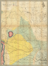
Rare and tragic map advertising the dismantling of the Great Sioux Reservation for white settlement by the Treaty of 1889, one of the direct causes of the Wounded Knee Massacre in 1890.
This map draws its importance from its ties to the Wounded Knee Massacre. The massacre was caused by reactionary white settlers who were concerned about the Sioux Ghost Dance, a prophetic movement that predicted the end of white settlement in the American West. This movement grew in the immediate aftermath of two events: the reduction of the Sioux lands nearly in half following a forced treaty (the Treaty of 1889, which is shown on the map); and the division of the remaining Sioux lands in 1890 contrary to terms of earlier treaties.
This map shows, in red, the lands that were imminently to be opened by the Treaty of 1889. They extend from North Dakota through to Kansas and total some 9,274,668 acres of formerly Sioux land. In addition, railroads, built and proposed are shown, as are cities. The county structure is shown.
The map belies who stood to gain from this expansion. Not only were the settlers to benefit, but also the railroad companies that would ferry them to these lands, sell them land, and act as their lifeline to the East. This map was published by the Chicago, Milwaukee & St. Paul Railway, which had already proposed an extension to its Chamberlain line that would cut straight through the heart of the former Sioux lands.
The Treaty of 1889, Westward Expansion, and Wounded Knee
The treaty of 1889 was the third and final treaty of the 19th century that ceded substantial portions of Sioux lands in the Dakotas to the United States. These three treaties resulted in the reduction of total Sioux lands from 58 million acres at the start of the 1850s to only 13 million acres in 1890. Meanwhile, white settlement was encroaching ever closer to the remaining Sioux lands.
The Sioux responded to these encroachments with the Sioux Wars, which started in 1854 and saw their conclusion with the Ghost Dance War of 1890. Perhaps the strangest of all affairs, the Ghost Dance War draws its name from a native American ceremony started by Paiute leader Wovoka (Jack Wilson) who saw a vision from God that he would be left in charge of the American West.
Wovoka's teachings gained rapid acceptance among the Sioux, who had been re-energized in their resentment of lost land following both the Treaty and the division of their remaining lands. This worried US military personnel, settlers, and members of the Indian Agency, although many specialists warned against hasty measures.
In response to this rapidly growing movement, the Indian Agent at Standing Rock interned several chiefs who participated in or might join this movement, among them Sitting Bull. Sitting Bull was killed while being taken into custody, which led to an armed band of Sioux fleeing.
Eventually, these Sioux, under the leadership of Spotted Elk, were caught by the US 7th Cavalry. They were about to be disarmed when some series of events, perhaps involving an attempt at performing a ghost dance and a misfire, gave the Cavalry cause to fire. Supported by light artillery, the Cavalry killed over 250 Sioux, many of them children.
Provenance
This map, along with another of the same region, came from a descendant of a Central and Eastern European family who considered emigrating to the United States in the 1880s.
Rarity
We trace only a single example of this map, at the Wisconsin Historical Society.
![[Red River Valley] Map of the Wheat Region Red River Valley and adjoining Countries in Dakota and Minnesota Published by A.J. Harwood, Fargo, D.T.](https://storage.googleapis.com/raremaps/img/small/70591.jpg)