|
||

|

|
|

|
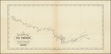
João Barbosa Rodrigues Investigates The Nhamundá River Region
Rare map of the Yamunda (Nhamundá) River in Northern Brazil, prepared in connection with the explorations and writings of João Barbosa Rodrigues (1842-1909), one of Brazil's most important Botanists.
Rodrigues undertook the first of his botanical expeditions in 1868. In 1871, he was commissioned to explore the Amazon basin and study palms, in part due to sponsorship by Austrian born Guilherme Schüch, the Baron of Capanema, who was responsible for the first telegraph line laid in Brazil. Rodrigues' 1871 expedition lasted more than three years, resulting in a diverse examination of indigenous plants, animals and Indian artefacts.
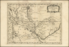
Nhamundá River or Jamundá River is partof the northeastern boundary between states of Amazonas and Pará. Beginning in the plateau Serra do Jatapu near the division of the Brazilian States of Roraima, Amazonas and Pará, the river flows southeastern, crossing the Nhamundá-Mapuera Reserve (before joining the Trombetas River near the city of Oriximiná. The river, which flows through the Lago Nhamundá, is the last major right-hand affluent of the Trombetas River before the Trombetas joins the Amazon River.
The three towns on the river's lower reaches (Terra Santa, Nhamundá, and Faro) are accessible only by boat.
![[Bahia de Todos Santos] t'Neemen van de Suyker Prysen in de Bay de Tode los Santos Anno 1627](https://storage.googleapis.com/raremaps/img/small/75293.jpg)
![Suite Du Bresil . . . [2 maps]](https://storage.googleapis.com/raremaps/img/small/103662.jpg)