|
||

|

|
|

|
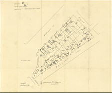
Fine and large original antique map of Budapest, showing the city limits and coloring the city according to neighborhoods.
This attractive map shows excellent detail regarding the city, with many roads, railways, parks, important buildings, and more all named. A legend in the lower right provides context. The map shows Budapest still very confined, with only slight expansion into the neighboring fields and undeveloped land.
This map is accompanied by a lengthy index of all the places shown on the map. In all, a remarkably detailed and attractive map for the period.
The map shows Budapest during a period of Hungarian turmoil and massive social upheaval. The recent end of the First World War led to the formation of the Hungarian Democratic Republic, which was quickly superseded by the Hungarian Soviet Republic, which itself only lasted a few months.
This map was originally drawn by Kogutowicz Manó in 1907 and updated with information by Czakó István in 1920. The map was published by the Hungarian Geographical Institute (the Magyar Földrajzi Intezet).
![[Part of Hungary]](https://storage.googleapis.com/raremaps/img/small/0009gh.jpg)