|
||

|

|
|

|
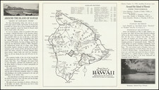
Two fascinating charts of the Hawaiian Islands, illustrating the charting of the islands by La Perouse and the compilation of the data from La Perouse and Cook's explorations in the Hawaiian Islands.
This historically important pair of maps records the first two major voyages of exploration to the Hawaiian Islands, by Cook and La Perouse. The first recorded European discovery of the Hawaiian Islands occurred on January 18, 1778, when the HMS Resolution and the HMS Discovery, sailing on Captain James Cook's Third Voyage, sighted both Kauai and Oahu. Accompanying Cook were three mariners who were to go on to gain considerable fame in their own rights; Lt. Henry Roberts, Master William Bligh (of the 'Mutiny on the Bounty' fame), and a young midshipman, George Vancouver. Cook named the chain the 'Sandwich Islands', after his patron, the Earl of Sandwich. This name would be gradually superseded during the nineteenth-century by the indigenous name 'Hawaii'.
While Cook's party spent the rest of the winter of 1778 in Hawaii, and returned the following winter, tragedy struck when Cook was killed during a skirmish with Hawaiians on Valentine's Day, 1779. Consequently, Henry Roberts, who drafted the expedition's map of the islands, was not able to complete the task, and consequently his "map of Hawaii consisted of portions of Kauai and Niihau, a rough outline of the southwestern coast of Oahu, the northeastern shore of Maui, and most of the island of Hawaii. Virtually the entire middle portion of the island group had yet to be explored" (Fitzpatrick, Early Mapping of Hawaii, p.19).
In 1785, the French, who both greatly admired and felt challenged by the momentous accomplishments of Cook, mounted their own Pacific expedition under the command of Jean-François de Galoup, the Comte de La Pérouse (1740-88). His party, sailing in the Boussole and the Astrolabe, first sighted the Big Island's snow-capped peaks on May 28, 1786, but elected to land on Maui, the first recorded landing by Europeans on that island.
The upper map shows the new discoveries in the central islands made by La Perouse's cartographer, as recorded by his cartographer Sebastian Bernizet. The map below represents Bernizet's efforts to synthesize Roberts' partial renderings of Kauai and Oahu to his own renderings of Maui and the Big Island.
While La Perouse's mission would perish in a shipwreck off Vanikoro in the Solomon Islands, fortunately, his papers and maps were given to the British in Australia for safe shipment back to Europe. The British honored their commitment to return the papers to France and La Perouse's maps were first published, along with an account of his voyages, in Paris in 1797. The present map is from the English edition of La Perouse's work, published in London the following year.
A fine example of one of the most historically important 18th Century maps of Hawaii.
![[Hawaii] Carte Des Parties Des Iles Sandwich . . . 1786](https://storage.googleapis.com/raremaps/img/small/81545.jpg)

![[Early Hand Drawn Map of the Hawaiian Islands]](https://storage.googleapis.com/raremaps/img/small/62429.jpg)