|
||

|

|
|

|
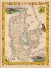
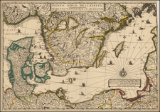
Striking example of Pierre Mariette's early map of the Kingdom of Denmark.
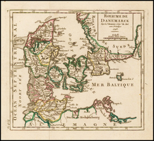
Marriette's map offers a detailed depiction of the Kingdom of Denmark as it was in 1646. Tthe map captures the territorial expanse of Denmark during the mid-17th century, a period marked by significant political and military developments. The map, adorned with an elaborate allegorical cartouche and the Danish coat of arms, provides not only a geographical representation but also an insight into the artistic and symbolic expressions of the time.
In 1646, Denmark was a formidable power in Northern Europe, ruled by King Christian IV. The 17th century was a tumultuous period for Denmark, characterized by its involvement in various conflicts and its efforts to maintain dominance in the region. One of the most significant events of this century was the Thirty Years' War (1618-1648), in which Denmark played a crucial role. Initially, King Christian IV entered the war to support Protestant interests in the Holy Roman Empire, but the Danish intervention led to military setbacks and territorial losses.
Despite these challenges, Denmark remained influential, particularly in the Baltic Sea. The kingdom's control extended beyond the Jutland Peninsula and the Danish archipelago, reaching into parts of modern-day Germany and Sweden. This map vividly illustrates these regions, some of which are no longer part of Denmark today.
The map highlights several areas that were under Danish control in 1646 but have since become part of other nations. Notably, the Duchies of Schleswig and Holstein, located in the southern part of the map, were integral territories of Denmark. However, following the Second Schleswig War in 1864, these duchies were ceded to Prussia and Austria. Today, they are part of Germany.
Similarly, the map shows the island of Rügen and parts of Pomerania, which were under Danish influence during this period. These regions are now part of modern-day Germany. The Danish influence in these areas was a testament to the kingdom's extensive reach and its strategic importance in controlling the Baltic trade routes.
![[Denmark and southern Sweden]](https://storage.googleapis.com/raremaps/img/small/75156.jpg)