|
||

|

|
|

|
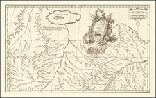
Pashto Map of Afghanistan
Impressive, large-format map of Afghanistan, showing the country's topography and hydrography, published by the Kabul Public Press, at a moment in time when Afghan leadership was actively attempting to compel more official publications in Pashto, rather than Farsi.
The map names the many regions of Afghanistan, and shows major roads. Detail extends into the neighboring countries. The borders of the nation are almost exactly the same as they are today.
The borders of Afghanistan had been set during the last decade of the 19th century, shortly before the making of this map, by Russian and English diplomats who viewed the territory as critical to the Great Game that was played between those two powers.
The map is dated to the year 1332 in the lower right, which is 1953 in the Shamshi calendar.
The map was created during the reign of Mohammad Zahir Shah, following the assassination of his father in 1933. Shah was 19 when he succeeded to the throne, which he held from 1933 to 1973. At the time the map was created, the ruling party was attempting to foster the growth and spread of Pashto, officially specified as the key language for government. Persian-language newspapers were required to publish pages in Pashto. Official patronage of Pashto was systematically attempted from 1953 to 1963, when Mohammed Daoud Khan (a prince and cousin of the king) was prime minister. According to Louis Dupree, an American anthropologist resident in Kabul:
Some non-Pashto-speaking high-ranking officials found it necessary to have clerks translate their Farsi communications into Pashto for transmission to another office. The recipient, often a non-Pashto speaker as well, handed the report to an assistant for translation back into Farsi. The scheme collapsed in a welter of translation and retranslation.
The map defines national borders, regional subdivisions, and the country’s limited infrastructure. And map historians have long pointed out that defining a nation cartographically can have an enormous influence and impact on actual reality. Consequently, this map was not just a nationalist project but a means for Afghans to familiarize themselves with their own country. Despite enormous regional influence at the time, there is not a single label in Farsi, English or Russian. This was an Afghan map for Afghan people.
![[Nepal] Latest Trekking Map North North of Jomsom Jomsom to Mustang](https://storage.googleapis.com/raremaps/img/small/44106.jpg)
![[ Northeastern Nepal ] Tamba Kosi-Likhu Khola](https://storage.googleapis.com/raremaps/img/small/95927.jpg)