Stock# 87519
Description
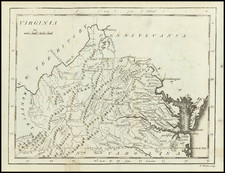
Scarce Charles Desilver map of Virginia, hand colored by county and showing towns, rivers, bays, lakes, railroads, roads, distances, forts, etc.
Tables of principal railroad and steamship routes and distances. Inset of the District of Columbia.
A scarce example of Desilver's map of Virginia.
![[Amherst County Survey of 200 Acres Owned by Captain James Dillard dated 16, 1822]](https://storage.googleapis.com/raremaps/img/small/73745.jpg)

![(American Revolution - Virginia Privateering) Manuscript Document Concerning the American Privateer Grand Turk, Captured Near Scotland's Fair Isle by Michael Griff [The Capt. of the Privateer Michael Griff declares as follows ...]](https://storage.googleapis.com/raremaps/img/small/82328.jpg)