
This item has been sold, but you can enter your email address to be notified if another example becomes available.


|
||

|

|
|

|
Stock# 87504
Description
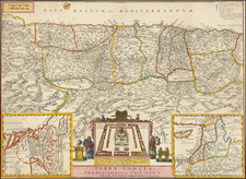
Original antique map of the Holy Land, focusing on the region now known as Israel.
The map shows the region divided according to the land held by the Twelve Tribes, each shown in a different color and name. Detail also shows rivers, population centers, and more. Two inset maps show the greater Middle East and the Sinai Peninsula, with the route of Egypt mapped.
This map was published in Scotland in the middle of the 19th century.
Condition Description
Original hand-color. Offsetting.

![[ Holy Land ] Das Heilig Landt mit außtheilung der zwölff Geschlechter](https://storage.googleapis.com/raremaps/img/small/100589.jpg)