


|
||

|

|
|

|
To the Ends of the Earth on a Suppressed Expedition
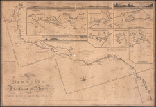
Striking, detailed chart of Patagonia and Tierra del Fuego, based on the observations of the suppressed Malaspina Expedition. This is one of the earliest of the few charts using information from the voyage to appear on the market.
The chart shows the coastlines from the Biobio River in Chile and the Pampas of Argentina to Cape Horn in the far southerly latitudes. The Malvinas, or Falklands, are included to the east. In many respects, this chart was the "gateway" chart to the grander purpose of the Malaspina Expedition, which was intended both as an Enlightenment motivated scientific endeavor meant to gather ethnographic and natural historical information from the far reaches of the Spanish empire and perhaps more importantly an assessment of the defensive and economic conditions of the Spanish colonies from Montevideo to the Philippines, including investigating the rumored Russian settlements in California and British colony in eastern Australia.
The routes of two ships, the Descubierta (Discovery) and the Atrevida (Daring), provide a wealth of sounding depths, notes on the quality of the bottom, magnetic variation measurements, and more. However, their commander and principal officers are not named; instead, the observations are attributed to “varios Oficiales de su Vl. Armada,” or various officers of His Majesty’s Navy.
The official who is named is Don Juan de Lángara, Minister of Marine and counselor to the King of Spain. Lángara was a skilled hydrographer who had distinguished himself in battles in European waters and on voyages to the Philippines and South China Sea in the late 1760s. He served actively until 1797, when he became Inspector-General of the Navy, hence his name on this chart.
The other officer mentioned on the chart is credited in the lower left corner with drawing the map. Felipe Bauzá y Cañas was a Spanish officer who hailed from Mallorca. Skilled in mathematics and hydrography, Bauzá was assigned to the Malaspina Expedition (1789-1794) and then served at the Depósito Hidrográfico from 1797. He became head of that organization in 1815. Political machinations later meant that he had to flee to Britain and his considerable chart collection was sold to various entities, including the British Admiralty, the British Museum, and the government of Venezuela. The chart was engraved by Ferdinand Selma, who worked closely with the Depósito.
The chart uses space effectively, filling the interior of southern South America with views of important locations like Cape Horn, Mocha Island, Cape Blanco, Port Desire, and others. There are also notes providing a key to the abbreviations used to describe the quality of the sea floor and the source of the coordinates used in the chart—they could have been observed on land or sea astronomically, by land or sea by dead reckoning and other means, or measured trigonometrically.
There is also a large inset of the northern section of the Gulf of San Jorge, or St. George, at the top of the chart. This geographic feature is included in its entirety on the eastern coast of South America, in what is today Argentina. It is a large, semi-circular gulf that terminates, in the south, at Cape Blanco.
The Malaspina Expedition
As the title explains, observations from a voyage in 1789, 1790, 1791, 1792, 1793, and 1794 provide the majority of the sources that underwrite this chart. However, the expedition itself is unnamed and shrouded in mystery.
After the large-scale scientific expeditions of James Cook and La Perouse, Britain and France had asserted their imperial intentions over the Pacific. The Spanish had long operated a closed-archive policy, claiming the Pacific as their own sphere but avoiding sharing geographic information that would prove their prior exploration of the area. This was all meant to change in July 1789, when Alejandro Malaspina sailed from Cádiz.
Malaspina and his fellow naval officer, José Bustamante, submitted a proposal to the Spanish Crown in 1788 outlining a grand plan, a scientific endeavor meant to gather ethnographic and natural historical information from the far reaches of the Spanish empire. The Crown approved and two new ships, the aforementioned Descubierta and Atrevida were laid in shipyards in preparation.
Alongside these scientific aims, however, were political objectives. Malaspina was to chart Spanish possessions from Montevideo to the Philippines, as well as to carry out a detailed assessment of the defensive and economic conditions of the colonies. He was also to investigate the rumored Russian settlements in California and the nascent British colony in eastern Australia.
Malaspina sailed first to Montevideo and then the Malvinas, before rounding Cape Horn. The ships then worked their way up the coast, stopping at ports like Guayaquil, Callao, and Acapulco. When possible, they sent shipments of specimens and charts back to Spain, to ensure a record of the voyage was not lost if the ships were damaged or lost.
In Acapulco, Malaspina received new orders telling him to hasten to Alaska, where they were to search for a Northwest Passage first mentioned by Lorenzo Ferrer Maldonado in 1588. Malaspina thought the information was apocryphal and resented being rerouted on a wild goose chase. All Malaspina found was a short inlet leading to the Hubbard Glacier; he called it Puerto de Desengaño, or Deceit Passage.
By the end of 1791, Malaspina was back in Acapulco, readying to sail across the Pacific. They stopped first at Guam, in the Marianas, and then came to the Philippines. Malaspina spent nearly nine months in the Philippines, while Bustamante took the Atrevida to Macao, a part of the voyage not shown here.
From the Philippines, the ships set out into the open Pacific. They briefly visited New Zealand and then spent a month at Port Jackson in Australia, where they made important observations of the penal settlement. Malaspina then charted Vava’u, in the Tongan archipelago, claiming it for Spain.
The ships returned to Callao and coasted south to Cape Horn once again. In the meantime, war had broken out with France. Malaspina decided to send his ships back separately to Montevideo, to lessen the chance that they would both be captured. They then returned together in consort with a frigate and trading vessels to Spain in September 1794, just over five years after they had left.
The lack of publication of the Malaspina expedition
Upon his return, Malaspina was disappointed at the lack of attention he and his fellow officers received. Spain was at war with France, and Malaspina quickly expressed his opinions about the political situation. He was also preparing the masses of reports, charts, and documents into what he planned as a seven-part voyage account complete with a hydrographic atlas and a folio-sized book of drawings.
This grand plan was never to be, however, as Malaspina was implicated in a conspiracy to topple the first minister, Manuel Godoy. Tried in absentia, Malaspina was sentenced to ten years in prison. He and his fellow officers were also ordered to stop work on the voyage account; they had to return all papers having to do with the expedition to the state.
The only one of the seven volumes planned by Malaspina that was published was of a subsidiary survey of the Strait of Juan de Fuca performed by Dionisio Alcalá Galiano and Cayetano Valdés. This work was intended to counter the claims posited in George Vancouver’s voyage account, published in 1798, but the Galiano and Valdés book was too little, despite including a fine atlas, and four years too late. Malaspina was not mentioned in the work; he was referred to only as the anonymous “commander of the corvettes.” While many of the botanical samples made it to the Real Jardín Botánico, few of the voyage artists and naturalists published their work.
The only other information that was published were the hydrographic observations. Individual charts, like this one, were published ad hoc—this is one of the earliest to appear. In 1809, Don Josef Espinosa y Tello published Memorias sobre las observaciones astronómicas, hechas por los navegantes españoles en distintos lugares del globo. Espinosa y Tello had served on the Malaspina expedition, joining them belatedly at Acapulco. In 1797 he was appointed as the first head of the Dirección de Hidrografía, a position he held until 1808. In the Memorias, Espinosa y Tello mentions Malaspina by name and used his journal in the Memoria Segunda, which covered the Americas and the Pacific.
Surprisingly, the suppression of Malaspina was so complete that the first publication of his journal was in Russian. It appeared as a serialized story in a Russian naval journal from 1824 to 1827, having been translated from Spanish to French to Russian. It was published in Spanish only in 1885, in a heavily abridged and edited edition by Pedro Novo y Colson. The entirety of Malaspina’s journal, with supporting documents, was only published in 1987-1999 in a Spanish nine-volume set that rightly returned Malaspina to a place of honor in the history of Pacific exploration. In English, a definitive edition of the journal was published by the Hakluyt Society in 2001-4.
Rarity
The chart is very rare on the market, with only one example appearing at auction and again in a dealer catalog listed by AMPR in the past thirty years (Warren Heckrotte Copy, sold by PBA Galleries in 2015 to Martayan Lan).
The Dirección de Hidrografía, or the Directorate of Hydrographic Works, was established in 1797. Its roots were in the Casa de Contratación, founded in 1503 in Sevilla, which housed all the charts of the Spanish Empire and oversaw the creation and maintenance of the padrón real, the official master chart. The Casa, now in Cadiz, was shuttered in 1790, but Spain still needed a hydrographic body. In response, the Dirección was created in 1797. One of its first projects was the publication of charts from the Malaspina Expedition (1789-1794). The Dirección oversaw not only publication, but also surveying. The Dirección was abolished in the early twentieth century, when their work was distributed to other organizations.
![[Straits of Magellan] Carte Reduite Du Detroit De Magellan Dressee sur les Journaux des Navigateurs; Par le Sr. Bellin . . . 1753](https://storage.googleapis.com/raremaps/img/small/68956.jpg)
![(Argentine Antarctic Territory) Republica Argentina Territorio Nacional de la Tierra del Fuego e Islas del Atlantico Sur [Argentine Republic, National Territory of Tierra del Fuego, Antarctica, and South Atlantic Islands.]](https://storage.googleapis.com/raremaps/img/small/94971.jpg)
