|
||

|

|
|

|
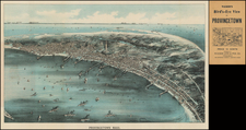
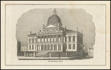
Showing Expansion of Massachusetts State House During Prior to It Completion in 1895
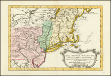
Russell's 1891 map of Massachusetts offers an engaging perspective of the state, blending geography with historical context. The map captures several aspects of Massachusetts, providing a well-rounded view of its structure and features.
The centerpiece of this map is the Massachusetts State House, engraved in fine detail. The State House's architecture, including its well-known dome, is depicted with precision. Of note is the representation of the State House extension, a later addition to the original structure. The architects of the extension, Brigham & Spofford, took on the task of expanding the structure without detracting from its original design.
The Massachusetts State House was built in 1798, based on the designs of Charles Bulfinch. Over time, the building required an extension due to the expanding needs of the government. Brigham & Spofford Architects undertook the extension project in 1889 and completed it in 1895. This period of construction is significant because it marks the transitional era captured within the 1891 map – a State House in the process of evolving to meet the demands of the day.
The rest of the map offers a color-coded division of Massachusetts by counties, aiding in clear geographical distinction. The variation in colors is visually striking and helps to easily separate one region from another.
Moreover, the map accurately outlines the state's transportation network. It marks railroads, post roads, and town roads, also indicating the distances between post stations. This gives a clear view of the pathways that connected different regions of the state.
In addition to transport routes, the map also shows the positions of money order post offices and ordinary post offices. These markers indicate areas of activity and communication within the state.
At the bottom left, a key details the population of Massachusetts based on the 1890 census, broken down by counties. This provides insight into the population distribution of the state at the time. It includes the population of the largest towns in each county, marking the significant urban areas of the period.
Rarity
The map is apparently very rare. OCLC locates only the copy at UC Santa Barbara.
Earlier Russell maps of Massachusetts are a bit more common.