


|
||

|

|
|

|
Rare First State.
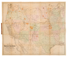
A nice example of the rare first state of William Keeler's large 1867 National Map, one of the most influential 19th-century maps of the American West.
In an accompanying text sheet (see bottom of description for full transcription), Keeler contextualized the map and the impetus for its production. The map was prepared within the Indian Bureau chiefly (but not exclusively) for official governmental uses. It had three primary focuses: railroads, economically-significant geology, and Indian reservations. Keeler understood these as the most salient themes in the West at the time.
To that end, Keeler provides a thorough compilation of data from many governmental sources, and, through color coding, he shows the locations of gold, silver, copper, quicksilver, iron, and coal. The map depicts completed and proposed railroad lines, as are land offices, forts, and military posts.
Critical Appraisal
Keeler's map has been described as the largest, finest, and most detailed map of the West as it was then known.
Martin & Martin say of the map:
In 1867, seeking to take advantage of public interest in all aspects of the West, but particularly the railroad routes, William J. Keeler, an engineer working in the Indian Bureau, published a large, attractive map of the entire country west of the Mississippi. As a product no doubt of Keeler's own employment with the Indian Bureau, the various Indian reservations were clearly shown and identified by a color scheme, an early use of this thematic device.
Wheat writes:
Keeler's map extends from Cincinnati to the Pacific, and from about the 32nd to the 42nd parallel--or from Ft. Reno in Wyoming to Ft. Filmore in New Mexico; It has a superior showing of new military data, being in advance even of the Colton maps (for example, Ft. Fetterman on the upper North Platte, Camp Douglas near Great Salt Lake City, Ft. Reynolds, Ft. Morgan, and Ft. Sedgwick in Colorado). It also displays, with color symbols, deposits of gold, silver, coal, copper, and quick silver from eastern Colorado to California--information . . . economically pertinent to railroad operations. But primarily it is interesting for railroad routes west of the Missouri; The Union Pacific is shown completed as far as Fort D.A. Russell, near Cheyenne, the projected route then going past Ft. Sanders on the Larame, and past Ft. Hallbeck to Bitter Creek; alterations of the route made west of the Larmie by Dodge and his engineers in the summer of 1867 had not yet come to Keeler's attention. The route goes on by Echo Canyon to the Great Salt Lake Valley, then swings north around the lake to the Humboldt, somewhere in the stretch becoming the Central Pacific R.R. The latter, somewhat prematurely, is shown completed down the Truckee almost to the great bend of that river.
What appears on this map as the "U.P.R.W.E.D." is represented as completed all the way to Ft. Wallace, near the west edge of Kansas (That was the expectation of the Company in the summer of 1867). Just beyond, inside the Colorado line, this road branches, one route going northwesterly to Denver, the other southwesterly to Arkansas and the Purgatorie, thence to Ft. Union and Albuquerque, and on to California via the route later actually employed by the Atchison, Topeka & Santa Fe. From Albuquerque yet another line follows down the Rio Grande, with an extensive western branch turning off at Ft. McRae to seek out California via the Gila. This latter branch is not labelled. Keeler's railroad map is full of factual information, but is also full of hope and faith.
William Keeler's map of the West is regarded as a landmark in the mapping of the region, providing the best detailed and comprehensive look at the Western railroad system after the close of the Civil War. His large map was widely distributed, and its influence on the history of the mapping of the Transmississippi West was profound.
Editions and States
1867.1 National Map of the United States (57.5 x 47.5 inches) - the present example
1867.2 National Map of the United States (57.5 x 47.5 inches)
1868.a National Map of the United States (37.25 x 29.5 inches)
1868.b National Map of the United States (22 x 28.5 inches), Wheat 1187
The present example of the map was an early (possibly proof) copy, pre-dating the addition of the Indian Reservations in and before 1867.
First, a number of the Indian Reservations which existed in or before 1867 and which appear in printed format on most examples of this map are not present in printed form, but instead have been hand written in by a contemporary hand. Some examples include:
- Yakama Reserve
- Grand Ronde (Oregon)
- Silitz Res. (Oregon -- spelled Salitz on the later printed versions)
- Warm Springs Res. (Oregon -- with no printed border--the later edition includes a printed border).
- Klamath Res. (Oregon - Shown and colored, but not named in the later version).
- Smith River Res. (California -- shown and colored, but not named in the later version)
- Klamath Riv. Res. (California)
- Hoppa Valley Res (California)
- Mendocino Res.
- Round Valley Res. (California)
- Nome Lackee Res (California)
- Makah Res. (Washington)
- Swanomish Res. (Washington)
- Snohomish Res.
- Duamish & Suquamish Res. (Washington).
- Skokomish & Selallam Res (Skokomish & Sklallam on the earlier map).
- Nisqually Res.
- Puyallup Res.
- Upper Yakama Res.
- Umatilla Res (colored on the earlier example, but not named).
- Bois Forte Chipps. (Minnesota)
- Sisseton & Warpeton Sioux Yanctonnais Sioux Cuthead Band (North Dakota)
- Unnamed Reservation near Pigeon River and Lake Superior (Minnesota)
- The Winnebago Reservation on the Missouri River appears only on the east side, whereas it appears on both sides on the later edition.
- The Yankton Reservation on the Missouri River appears only on the north side of the river, whereas it appears on both sides on the later edition.
- Canadian District (south of Ft. Gibson (Indian Territory)
- Osage Trust Lands (SE Kansas, west of the Arkansas River)
Second, for Reservations created after 1867, the region is highlighted in red and includes dating and details in manuscript:
- Proposed Reservation for Gros Ventre, Piegan, Blood, Blackfeet & River Crow Inds. Treaty 1868
- Reservation set apart for Different Tribes of Sioux Indians Treaty April 29, 1868 Proclaimed February 24, 1869
- Reservation for the Tabeguache Muache Capote Weeminuche Yampa Grand River Uintah Bands of the Ute Indians Treaty March 2, 1868. Proclaimed Nove 6, 1868.
- Reservation for the Navajo Indians Treaty June 1, 1868, Proclaimed August 12, 1868.
- Reservation for Arapahoes & Cheyennes Treatly Oct. 28 1867.
- Reservation for Kiowa, Comanche Apache Indians Treaty Oct. 21, 1867, Proclaimed Aug. 25, 1868
- Reservation for the Osage Ind. Treaty May 27, 1867
- Canadian District
There is also a section indicating Land Ceded to the US
- Ceded to the U.S. by the Choctaws and Chickasaw April 28, 1866
- Choctaw & Chickasaw Cession between Middle and North Fork of the Red River
Appendix: Accompanying Text
The following text appears as a pastedown in the front covers of some of the Keeler map covers. It also appeared in contemporary newspapers.
This National Map of the Territories of the United States, from the Mississippi River to the Pacific Ocean, was made by authority of the Hon. O. H. BROWNING, Secretary of the Interior, in the office of the Indian Bureau, chiefly for Government purposes. It is compiled from authorized explorations of the Pacific Railroad Routes, from public surveys, and other reliable data in the department at Washington, D. C.. by W. J. KEELER. Civil Engineer, under the direction of the Hon. N. G. TAYLOR, Commissioner of Indian Affairs, and Hon. CHARLES E. MIX, Chief Clerk of the Indian Bureau.
Coming from such a source, and based upon such data, it is unnecessary to vouch for its accuracy and reliability. It is a complete Railroad Map, the only one published which shows the whole of the great Pacific Railroad Routes and their projections and branches, together with all other railroads in the States and Territories bordering on the Mississippi on both sides, showing at a glance the eastern connections of these Pacific roads with the on existing railroad systems of the country.
It shows the Township and Range Lines of all public land surveys up to date; the Indian Reservations, Forts, Military Posts, etc. To all who own or deal in western lands this is a most valuable feature.
The location of all the known mines of gold, silver, copper, and other valuable metals, are carefully and accurately noted. These mineral localities are scattered all over that immense region, from the line of the British Possessions on the north, to Mexico on the south, and from the eastern slope of the Rocky Mountain range almost to the shores of the Pacific. Of the ultimate value of these widely extended depositories of the precious metals no estimate can be made; but that they are destined to exert a mighty influence upon our country and upon the entire world, as indeed they have already done, is beyond question.
It is the attraction of these hidden treasures, more than anything else, that is drawing these great lines of railroad across the Continent; and in those treasures, the enterprising men who are urging those magnificent works forward, have their surest guarantee of success.
The profound interest now felt by the whole American people in the great thoroughfares progressing or projected, in the Indian troubles, in the rapid advance of settlement, and in the development of features of grandeur and beauty, and new sources of national wealth, will cause this Map to be hailed as a source of instruction and enjoyment by all, and as a valuable acquisition to the school and the library.
Particular attention is invited to the Colorado river as here shown. It is from actual survey, and exhibits that magnificent stream as it has never been mapped before, and as it really is, one of the great rivers of this Continent.
ADDRESS: W. J. KEELER,
Indian Bureau, Washington, D.C.
![[First California Wine Making Image] The Vintage In California -- At Work At The Wine Presses](https://storage.googleapis.com/raremaps/img/small/89054.jpg)
![Central Route to the Pacific, From The Valley of the Mississippi To California. Journal of The Expedition of E.F. Beale, Superintendant of Indian Affairs In California, And Gwinn Harris Heap, From Missouri To California [with map:] Map of the Central Route from the Valley of the Mississippi to California](https://storage.googleapis.com/raremaps/img/small/99222.jpg)
![(California-Mexico Border Survey) Datos de los trabajos astronómicos y topográficos. [bound with:] Variedades de la civilizacion, nueva epoca (Tomo I)](https://storage.googleapis.com/raremaps/img/small/70777.jpg)