![[ Philadelphia -- Capital of the United States ] To Thomas Mifflin Governor and Commander in Chief of The State of Pennsylvania This Plan of the City and Suburbs of Philadelphia . . . 1794 By Antoine Pierre Folie](https://storage.googleapis.com/raremaps/img/small/99834.jpg)


|
||

|

|
|

|
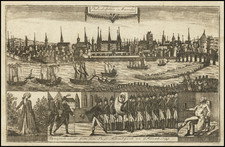
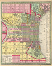
A superlative example of the first great street plan of Philadelphia published after the end of the Revolutionary War, while it was serving as the interim national capital before the move to Washington in 1800.
The plan shows the built-up area of the city facing the Delaware River, from “Part of Kensington” downriver to Southwark and inland to Eleventh Street. Thomas Holme’s rectilinear street grid, first laid out in 1682-3, continues to the Schuylkill River, but contrary to expectations much of the city’s expansion was up- and downstream along the Delaware rather than west to the Schuylkill. An extensive legend at upper left identifies 64 principal buildings, among them Peale’s Museum (7), the President’s House (24), the Bank of the United States (32), and dozens of places of worship, including the “African Meeting House” (18) and “Jewish Synagogue” (48). Ornamenting the map are the Philadelphia city seal, the foliate cartouche around the title, and a perspective view of the City Hall, State House, and Congress Hall. The stellar early wash color adds greatly to the map’s visual appeal, and indeed this is the finest example of which I am aware.
Interestingly, not one but two refugees from St. Domingo undertook to produce plans of Philadelphia in the 1790s. One by Charles Varle was probably published in 1796, but is inferior in detail and design to that offered here.
History of the Plan
Mapmaker A.P. Folie, sometimes described as “Antoine Pierre”, described himself as a French Geographer when announcing his intention to publish a plan of Baltimore (Maryland Journal, March 12, 1793) and later as from St. Domingo, presumably a refugee from the slave revolt on the island that began on August 21, 1791. It is believed that he arrived in Philadelphia by 1792.
Folie undertook an original survey of Philadelphia, presumably commenced in 1793, in conjunction with the Philadelphia bookseller and publisher Benjamin Davies. Davies announced the project, with a lengthy description of the map, thus,
PROPOSALS FOR PUBLISHING BY SUBSCRIPTION, A Ground Plan OF THE City Philadelphia, AND ITS ENVIRONS: Taken from actual survey, by A.P. FOLIE, Geographer, from St. Domingo. THIS Plan will be engraved on a plate 26 inches square; and it will contain an exact description of all the squares, streets and alleys in the City and Liberties. The situation of the several public buildings, such as the State-House, City-Hall, Seat of Congress, Churches, Meeting-Houses, Hospital, Library and Seminaries of Learning — of the several Banks, and of the Federal and State Offices, will be ascertained. The parts which are built on will be distinguished from those that are not. The courses of the rivulets between Delaware and Schuylkill, and as much of the Canal, intended to connect the navigation of those two waters, as lies within the compass of the draught, will be accurately delineated. It will also be ornamented by a view of the shipping in the harbor, and an elevation of Congress-Hall, and of the other public buildings that occupy the ground contiguous. In short, nothing will be omitted to render this useful and desirable work acceptable to an enlightened public, that is in the author’s power …
Further, he promised that
A Pamphlet will be delivered with each Plan, which will contain an alphabetical list of the Subscribers names, and information concerning the police, population and present state of the city. The price to subscribers will be Two Dollars and one third, to be paid at the time of delivering the Plans. (Gazette of the United States, issue 525, page 2, for February 28, 1794)
Davies also noted that publication would begin once a sufficient number of subscribers had come forward to underwrite the expense, and invited would-be subscribers to visit his shop to see the original draft.
On April 12, 1794, Davies registered his copyright for the plan (Pennsylvania District Court Ledger, 262 PA 45) and announced that the map was in the hands of the engraver (Gazette of the United States, April 14, 1794). Both the map and pamphlet were published later that year, the map announced in the Gazette of the United States for November 11, 1794,
JUST PUBLISHED, And to be sold by Benjamin Davies, No. 68, Market street A Ground Plan OF THE City, and Suburbs of PHILADELPHIA. Taken from late and accurate survey. This MAP is 26 inches square; and will be delivered as may best suit the purchasers, either in sheets plain or coloured, or canvassed and affixed to rollers; or to fit them for the pocket, they will be cut and folded in cases (issue 680, page 3)
This is the first state of the map, not noted by Wheat & Brun, before the addition of the labels for the buildings in the inset profile. The map was reissued a quarter-century later by Robert Desilver, with many updates reflecting the city's growth in the interim years. (Bloomsbury, Jay T. Snider Collection, Nov. 19, 2008, lot 237)
More on A. P. Folie
After the publication of this plan of Philadelphia Folie disappears from sight, appearing in lists of undelivered mail in Philadelphia in that year. He is assumed to be the “A. F. Folie” recorded in a list, dated December 31, 1808, of undelivered mail held for collection at the Philadelphia Post Office (Aurora General Advertiser, January 4, 1809, page 3).
Folie is known for the two printed maps mentioned above – Baltimore and Philadelphia – but a French engineer Claudius Fallize, advertising, his drawing and painting academy, announced that he “thinks it his duty to advise the public, that the draughts of the island of St. Domingo, which are for sale in the town under the names of Folly (i.e. Folie) and Varlet (i.e. Pierre Charles Varle, are false, being a bad copy of the one drawn by him” (Pennsylvania Gazette, issue 1935, page 1, May 23, 1795). The Folie map is unknown, and presumably existed only in manuscript.
In light of their collaboration on the Philadelphia map, Folie likely produced maps of St. Domingo advertised by Davies also in 1794:
“A Few Manuscript Maps of the French part of the Island St. DOMINGO, executed with great neatness, distinguishing in a plain and correct manner, the several departments, parishes, ports, capes, bays, rivers, &c. in that part which lately belonged to the French nation; may be had of BENJAMIN DAVIES” (Dunlap’s American Daily Advertiser, issue 4714, supplement page 2, for May 21, 1794).
Rarity
The map is extremely rare on the market.
We are aware of one other example (uncolored) at auction in the past many decades (2008, Bonhams, Jay Snyder Sale, referencing Martin P. Snyder as the provenance).
Separately issued examples of the first state: Free Library of Philadelphia; Harvard Map Collection, on two uncut sheets; Historical Society of Pennsylvania; New York Public Library; and Yale’s Beinecke Library.
Second state held by the John Carter Brown Library and New York Public Library.