|
||

|

|
|

|
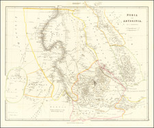
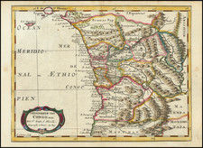
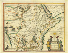
Rare Colonial-Era Touring Map of Congo, Kenya, Uganda, and Tanganyika (Tanzania)
Large and early touring map showing the distribution of roads throughout East Africa, focusing on the Belgian Congo but also extending into neighboring colonies. In addition to its extensive detail, one of the many interesting features of the map is the inset map of early flights connecting Leopoldville, Stanleyville, and Elizabethville.
The map focuses on the roads that crisscross this region of Africa, one of the last to be colonized and only after the Berlin Conference. Initially, control over this area relied solely on the rivers, which proved the only path through the dense jungle. However, in the interbellum period, the advent of roads and planes changed the nature of colonization. As shown on this map, it also allowed more Europeans to visit the region for pleasure. This was the start of the democratization (if it can be so called) of safaris and European tourism to this region.
The building of roads did not only impact the tourism industry. Laurence Heindryckx, of Ghent University, describes the growth of roads in the interwar Belgian Congo as follows:
"Compared to the railroad and fluvial networks, road infrastructure remains a blank spot in the historiography of colonial planning in Congo, and by extension, in the entire continent. Nonetheless, the colonial road network was used to efficiently carry out the health care program, tax system, postal service, and the military control system, which Freed called the ‘networks of colonial power’ (Freed, 2010)."
However, Heindryckx argues that, while a tour of empire, roads were uniquely responsible for opening up the most rural parts of the Belgian Congo and reshaping the community life in the colony.
Rarity
Colonial era touring plans and road maps of central Africa are uncommon to see on the market.
This map is itself rare. OCLC locates copies at Cornell, University of Wisconsin, Cambridge, and UPenn. We locate an additional example at the University of Ghent.
![Carte Routiere de Madagascar et dependances [set of 4 folding maps]](https://storage.googleapis.com/raremaps/img/small/89247.jpg)