This item has been sold, but you can enter your email address to be notified if another example becomes available.


|
||

|

|
|

|
Stock# 86541
Description
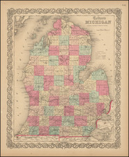
Only the Third Known Example. No Copies of this First Edition in OCLC.
Rare separate map of Michigan issued in New York by Ensign, Bridgeman, and Fanning in 1855.
The map shows considerable development in the southern half of the state, but little activity (especially naming of townships), in the northern half. Railroads stretching out from Detroit are illustrated.
An inset in the upper right corner is titled "Map of the Western Portion of Michigan".
OCLC locates only a 1857 edition, at Michigan State, however Karpinski notes examples of the 1855 first edition at University of Michigan and Wisconsin Historical.
Condition Description
Original hand-color by county, somewhat sun-faded. Small repaired loss where previously mounted and folding into boards. Original folder present. Some minor wear to folds and fold intersections. Other scattered faint stains. Good to VG.
Reference
Karpinski (1931) 197, noting examples at the University of Michigan and Wisconsin Historical.

![[ Great Lakes - Upper Midwest -- Western Canada ] Partie Occidentale Du Canada, contenant les cinq Grands Lacs, avec Pays Circonvoisons](https://storage.googleapis.com/raremaps/img/small/98377.jpg)