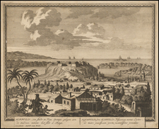
|
||

|

|
|

|
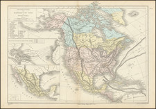
This 1859 map, titled Cornell's Outline Maps No. 7, produced by G. Woolworth Colton to complement Cornell's Series of School Geographies and published by D. Appleton & Co of New York, provides an engaging and instructive representation of Mexico, Central America, and the Caribbean. Notable for its use of numbered dots and stars scattered across the map, this geographical depiction presents an intriguing educational tool designed for scholastic study.
This map originates from an era marked by the vigorous expansion of public education in the United States. With the growing democratization of learning, educational materials such as Cornell's Outline Maps became pivotal instruments in classrooms, allowing students to engage with the world beyond their immediate environment. In this historical context, the map's focus on Mexico, Central America, and the Caribbean underscores the increasing importance of these regions to the United States, whether through trade, territorial expansion, or diplomatic affairs.
The numbered dots and stars on the map, presumably correlated with corresponding textual information in Cornell's Series of School Geographies, serve as an interactive feature, potentially facilitating a better understanding of geographical features, historical events, or societal phenomena relevant to the regions depicted. This educational approach reflects an innovative pedagogical style for the time, focusing on interactive and visual learning.
As a work by G. Woolworth Colton, Cornell's Outline Maps No. 7 exemplifies the cartographer's dedication to clarity, precision, and functionality. This map offers not only a snapshot of the geographic understanding of Mexico, Central America, and the Caribbean in the mid-19th century, but also an insight into the educational practices and pedagogical approaches of the time. It stands as a valuable artifact of historical geography and the history of education.
G. W. & C. B. Colton was a prominent family firm of mapmakers who were leaders in the American map trade in the nineteenth century. The business was founded by Joseph Hutchins Colton (1800-1893). who bought copyrights to existing maps and oversaw their production. By the 1850s, their output had expanded to include original maps, guidebooks, atlases, and railroad maps. Joseph was succeeded by his sons, George Woolworth (1827-1901) and Charles B. Colton (1831-1916). The firm was renamed G. W. & C. B. Colton as a result. George is thought responsible for their best-known work, the General Atlas, originally published under that title in 1857. In 1898, the brothers merged their business and the firm became Colton, Ohman, & Co., which operated until 1901, when August R. Ohman took on the business alone and dropped the Colton name.
![[ Baja California / Gulf of California ] Carta Esferica de las Costas y Golfo De Californias Llamado Mar De Cortes Que Comprende desde el Cabo Corrientes hasta el Puerto de San Diego Construida …. 1825](https://storage.googleapis.com/raremaps/img/small/102732.jpg)