This item has been sold, but you can enter your email address to be notified if another example becomes available.


|
||

|

|
|

|
Stock# 85640
Description
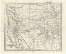
Scarce 19th-century atlas map of the Plains and Upper Midwest issued by H.H. Lloyd, and here reissued by Warner & Beers.
The map shows towns, railroads, rivers, etc. as railroads were just opening up the Plains to a large influx of white settlers.
Condition Description
Original hand-color by county. Toning on the left edge.

![Carte Du Canada ou de la Nouvelle France et des Decouvertes qui y ont ete faites . . . [Map of Canada or New France and the Discoveries Made Therein . . .]](https://storage.googleapis.com/raremaps/img/small/94450.jpg)
![Charte von Den Vereinigten Staaten von Nord-America nebst Louisiana . . . 1805 [Rare 1st State of Gussefeld's Louisiana Purchase Map]](https://storage.googleapis.com/raremaps/img/small/63496.jpg)