|
||

|

|
|

|
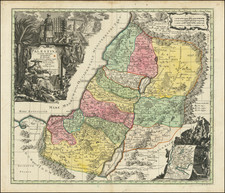
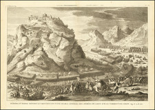
Nice example of this scarce historical map of the Holy Land, showing the land promised to Abraham. The map was published in France by de Vaugondy in 1743.
The main map includes a detailed look at the Holy Land, divided according to the ownership of the Twelve Tribes. The detail is nice, with many mountains, cities, and Holy Sites developed throughout.
In the upper left an inset shows the "Carte des Voiages d'Abraham faits par l'ordre de Dieu, en Asie et en Egypte" or the travels of Abraham throughout Egypt and the Middle East. The map shows the Garden of Eden.
Another inset in the lower left shows the positions of the Twelve Tribes around the Temple.
There is an illustration of the Ark of the Covenant in the lower-right corner.
Gilles Robert de Vaugondy (1688-1766) and Didier Robert de Vaugondy (1723-1786) were influential figures in the realm of 18th-century French cartography. Originating from Paris, their contributions to mapmaking were significant during an era of expansive geographical exploration.
Gilles Robert de Vaugondy entered the world of cartography not through family tradition but through personal interest and the budding opportunities of his time. Born in 1688, he worked during a time when Paris was becoming a central hub for cartographic activities. Gilles often incorporated the latest findings from explorers into his maps, making them sought-after for their contemporary relevance. His connections weren't limited to his immediate circle; he frequently interacted with other key mapmakers, staying updated on the latest techniques and findings.
His son, Didier, was born in 1723 and had the advantage of growing up surrounded by maps and globes. While his father was renowned for maps, Didier made a name for himself in the field of globemaking. His globes were some of the most precise and detailed in France, gaining recognition even among the royalty. In addition to his work in cartography and globemaking, Didier had a keen interest in education, especially after the expulsion of the Jesuits from France. He stepped in to produce geographical educational materials, fulfilling a newfound need.
The maps and globes produced by the Vaugondys remain an enduring testament to the peak of French cartography during the Enlightenment. Their works, characterized by precision and the inclusion of contemporary findings, helped to shape our understanding of the world during a transformative period in European history.