This item has been sold, but you can enter your email address to be notified if another example becomes available.


|
||

|

|
|

|
Stock# 85433
Description
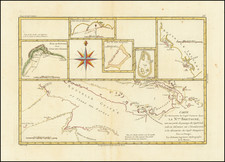
Rare early 19th Century example of James Burney's map of the Philippine Islands and contiguous regions.
The present map was intended to illustrate the route take by Ferdinand Magellan through the islands, based upon Burney's research.
James Burney (1750-1821) was a rear admiral, who began his career on the last 2 of Cook's voyages of Circumnavigation. The map appeared in his Chronological History of the Voyages and Discoveries in the South Sea or Pacific Ocean (London, 1803–1817).
![(Second World War) Your Submarine Versatile Warship [on verso:] NEWSMAP For the Armed Forces 268th Week of the War - 150th of U.S. Participation](https://storage.googleapis.com/raremaps/img/small/95106.jpg)