|
||

|

|
|

|
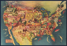
Decorative large format map of North America, featuring 14 vignettes of indigenous people and scenes and two vignettes of flora. The map is taken at one of the most historically and geopolitically interesting periods in North American history. Alaska is still Russian America. Canada is still controlled by the British. Oregon Territory, California, Utah and New Mexico still dominate the west. A massive Northwestern (Missouri) Territory is shown, a few years after it became Nebraska Territory. A massive Indian Territory in the tomahawk configuration is shown. The map includes very detailed listing and location of the indigenous Indian Tribes, as well as locating the types of fish which can be found in the coastal waters, the land types and a much more unique regional information. A highly sought after map from Vuillemin's now extremely rare large format atlas. A nice example with the vignettes in modern color, as usual. Minor fold splits top and bottom and the usual wear from having been housed in an oversized binding, yet an attractive example.
![[Collection of 10 manuscript charts and maps depicting the west coast of North America from Monterey, California, to just north of Salisbury Sound, Alaska.]](https://storage.googleapis.com/raremaps/img/small/98898.jpg)
![Carte Du Canada ou de la Nouvelle France et des Decouvertes qui y ont ete faites . . . [Map of Canada or New France and the Discoveries Made Therein . . .]](https://storage.googleapis.com/raremaps/img/small/94450.jpg)