


|
||

|

|
|

|
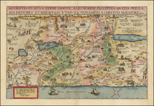
Striking large map of the Holy Land and Eastern Mediterranean, showing the wanderings of the Apostles throughout the Holy Land and the Eastern Mediterranean, with various explanatory notes.
The map includes a large inset of the Holy Land and a town plan of Jerusalem, based upon Villalpando.
Based upon a similar map published in Paris by Sanson.
Pierre, or Pieter, Mortier (1661-1711) was a Dutch engraver, son of a French refugee. He was born in Leiden. In 1690 he was granted a privilege to publish French maps in Dutch lands. In 1693 he released the first and accompanying volume of the Neptune Francois. The third followed in 1700. His son, Cornelis (1699-1783), would partner with Johannes Covens I, creating one of the most important map publishing companies of the eighteenth century.

![[Jonah Negotiating His Embarkation] Quid demens latebras circumspicis alterum in orbem. Si fugirs Dominum, non tamen effugies. Cui tellus paret, summus cui militat aether, Non parere putas huic etiam Oceanum](https://storage.googleapis.com/raremaps/img/small/85070.jpg)
![Turquie en Asie [Shows Cyprus]](https://storage.googleapis.com/raremaps/img/small/87678.jpg)
![[Tribe of Zebulon] Zebulon ad Portum Marium Ipse ad Portu Marium Habitabit](https://storage.googleapis.com/raremaps/img/small/85057.jpg)
![[Tel Aviv - Yafo] A View of the City and Port of Joppa at Present Called Jaffa. According to our modern Travellers](https://storage.googleapis.com/raremaps/img/small/89073.jpg)