


|
||

|

|
|

|
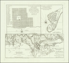
Scarce map of Portobello, Panama, by one of the great Spanish cartographers of the Caribbean and Central America, Tomas Lopez. The map shows a small town on the Atlantic coast of Panama, Portobelo, and the harbor that it sits on.
Portobelo, at the time, was one of the most important ports in Central America and hotly contested by regional powers. At the start of the 18th century, it was the site of the greatest British success in the War of Jenkin's Ear.
The upper map draws its geography from the map published by Juan Antonio de Ulloa in his Relacion de la America Meridional. The lower map draws its geography from Jeffreys. Both maps are nicely detailed, showing topography, soundings, individual buildings (with a legend), and more.
Portobelo, Panama
Today, Portobelo is a small town with just the ruins of the fort to remind visitors of a time when it was a busy, and hotly contested, port. The site that would become Portobelo was visited by several early conquistadores, including Christopher Columbus, but it was not settled until the end of the sixteenth century.
In 1586, the engineer Juan Bautista Antonelli began to fortify the natural harbor, in order to make it a protected outpost of the Spanish empire. He suggested the abandonment of the nearby settlement of Nombre del Dios in favor of the more easily-defensible Portobelo. This process was accelerated when Francis Drake attacked Nombre de Dios in 1596, causing the settlers to flee. This was actually Drake’s second sacking of Nombre de Dios, the first had been in 1573. A fire, also in 1596, convinced the merchants and their families to develop Portobelo instead.
The city of San Felipe de Portobelo was officially founded in 1597. Although defensible, Portobelo proved a tempting target for privateers, pirates, and navies in opposition to Spain. In 1602, Captain William Parker, a pirate, attacked, followed by Henry Morgan in 1671, who caused significant damage. Portobelo was again harassed, and again by English sailors of dubious reputation, in 1679, when a group including Bartholomew Sharp and the pirate-authors William Dampier and Lionel Wafer came to the harbor. The focus on Portobelo was justified, as the town was the staging place for Spanish silver to be brought from Panama to Havana. Finally, and most famously, Vice-Admiral Edward Vernon bombarded the town in 1739—the subject of this plan.
Tomás López de Vargas Machuca (1730-1802) was one of Spain’s most prominent cartographers in the eighteenth century. He was born in Toledo but studied at the Colegio Imperial in Madrid, where he focused on mathematics, grammar, and rhetoric. Along with a small group of colleagues, in 1752 the Spanish government sent López for training in Paris with the renowned geographer Jean Baptiste Bourguignon d’Anville. When he returned to Spain he was named Geógrafo de los dominios de Su Magestad and put in charge of the geographic collections of Charles III. He published many maps, including his fascinating maps of the Americas, and a variety of geography manuals. Some of his most famous maps are of the Iberian Peninsula, part of his large project to create a majestic atlas of Spain. Unfinished in his lifetime, López's children published the Atlas Geográfico de España (Geographical Atlas of Spain) in 1804. It was republished in 1810 and 1830.
![A Map of British Honduras... [bound in:] Tratado de Limites Entre Los Estados-Unidos Mexicanos y Honduras Britanica Seguido de los principales documentos que a el se refieren. Edicion Oficial.](https://storage.googleapis.com/raremaps/img/small/70984.jpg)

![[Hand Drawn Map] Le Golfe de Mexique avec les Pays Circonvoisins](https://storage.googleapis.com/raremaps/img/small/91580.jpg)
![Amer. Sep. No. 71. Partie Du Mexique et de Guatemala [Oaxaca, Tabasco, Chiapa, Verapaz]](https://storage.googleapis.com/raremaps/img/small/96583.jpg)