|
||

|

|
|

|
Stock# 84614
Description
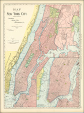
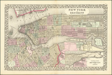
Interesting antique Humphrey Phelps map of Manhattan from the Battery to 32nd Street, with Williamsburg and Brooklyn Heights to the east (bottom).
Inset maps of upper Manhattan and Jersey City are positioned in the upper-left corner of the map.
The map locates three "Fire Alarm" districts, each divided into two sections.
The map was popular in the 1840s and was published for several years.
The map includes a note that it was "Drawn & Engraved by Story & Atwood, 151 Fulton St. N.Y."
Condition Description
Folding map. Original hand-color by ward. Some offsetting. Original embossed cloth case.
Reference
Haskell 867.