This item has been sold, but you can enter your email address to be notified if another example becomes available.


|
||

|

|
|

|
Stock# 84362
Description
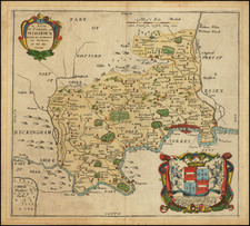
Valk and Schenk's decorative and attractive map of Northamptonshire, printed at the end of the 17th century. Nicely detailed, this map shows the county divided into its hundreds.
The map includes a number of decorative elements, including two cartouches, a royal coat of arms, and eight additional coats of arms. In the county, hills, forests, walled gardens, and more are depicted. In the northeast, Peterburouhg is termed "Peterburg." Clyff Park is shown near Newton, a former extensive aristocratic estate.
Detail extends into the neighboring counties of Leicestershire, Huntingdonshire, Bedfordshire, Buckinghamshire, and Oxfordshire.
Condition Description
Original hand-color in outline, with later coloring in the cartouches.
![Channel Islands [Guernsey and Jersey]](https://storage.googleapis.com/raremaps/img/small/46638.jpg)