|
||

|

|
|

|
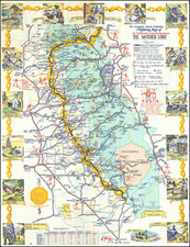
Virginia Seashore and the World's Longest Bridge Over Water
Scarce pictorial map of the area served by the newly constructed James River Bridge, published to promote local tourism.
In the early 20th century, Virginia stood at the crossroads of historical legacies and modern developments. While the region had been home to some of America's earliest settlements and decisive moments, by the 1920s, it was also eyeing its future as a tourism hotspot.
The map draws attention to its main focus - the newly built James River Bridge. By the late 1920s, this impressive structure spanned 4.5 miles across the James River and was celebrated as the world's longest bridge over water. This monumental feat of engineering was not only an emblem of progress but also served as a key conduit to the region's coastal attractions. With the bridge's opening, Newport News, Virginia Beach, and other coastal gems were more accessible than ever before.
The map itself is a detailed representation of eastern Virginia, stretching from Jamestown and Williamsburg in the west to Cape Charles and Virginia Beach in the east. Major highways crisscross the expanse, guiding potential visitors through scenic routes and past iconic landmarks. The accompanying text paints a vivid picture of the region's rich history, inviting tourists to delve into the stories that shaped the nation. Whether it was the first English settlers' footsteps in Jamestown or the echoing reverberations of the American Revolution in Williamsburg, Virginia's historical tapestry was laid out in all its glory.
The map's aesthetic appeal is heightened by the inclusion of a decorative compass rose. This ornamentation adds a touch of classical cartography, hearkening back to the times of explorers and sea voyages, reminding viewers of Virginia's pivotal role in the age of discovery.
The verso of the map provides practical information for would-be travelers. "Scenes from Virginia's year round playground" promises picturesque moments awaiting visitors. Additionally, a "Partial list of tourist accommodation" suggests places to rest, thereby painting Virginia as not just a site of historical importance, but also a comfortable holiday destination. Three ancillary maps provide details on motor routes, showcasing the ease of access to the Virginia seashore, with insets offering insights into regions like Richmond and the Norfolk area. Notably, a map detailing both the ferry and bridge crossing of the Elizabeth River underlines the area's connectivity and infrastructure.
While the James River Bridge's construction was a marvel of its time, it also serves as a testament to the challenges of pioneering ventures. Despite its initial fanfare and aggressive promotional campaigns like the publication of this map, the James River Bridge Corporation couldn't sustain the expected volume of traffic. It eventually filed for bankruptcy in 1933, a mere five years after the bridge's completion.
![[WWII War Bonds] As](https://storage.googleapis.com/raremaps/img/small/63461.jpg)