


|
||

|

|
|

|
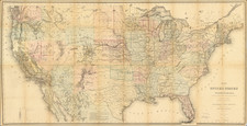
Immediately Prior to Wyoming Territory -- Tracking The Transcontinental Railroad Progress in the West
The Jacob Merritt Howard Copy -- Chairman of the US Senate Pacific Railroad Committee
Scarce early state of this highly detailed large format map of the United States, illustrating the extent of the public surveys conducted by the General Land Office through 1867.
The map is a magnificent overview of the progress of the railroad lines, western mining regions and progress with Native American Treaties in the west. Updated annually beginning in 1866, the map provides an up to date overview of the American west.
The map depicts the brief period prior to the creation of Wyoming Territory, when the future Wyoming Territory (and part of Montana at the far west) was still "attached to Dakota Territory."
The map provides a fine depiction of the newly discovered gold regions in Idaho and Western Montana. The Indian Cessions in Oregon appear for the first time, including Snake Cession and Klamath and Modoc Cession, as well as the Umatilla Reservation. The Yakima Reservatioin appears for the first time in Washington Territory. In Montana, the Upper Pend Oreille Reservation appears for the first time, as does the Black Foot and Assinboins Common Hunting Ground.
In Colorado, the lands claimed by the Grand River Utes are shown, as the the Tabequache Ute Reservation, with the land to the west noted as having been ceded by the Tabequache Utes in 1863. The lands ceded by the Cheyenne and Arapahoes west of the Denver area also appears for the first time.
The map also shows for the first time the progress of the transcontinental railroad, with an a American flag marking the progress of the line every 100 miles from Fort Kearney area (200 miles) to Fort Halleck (600 miles), 100 miles west of Cheyenne City, with the rest of the railroad route to the west marked as "Proposed Middle Route of the Pacific R.R." The remaining 500 miles to Salt Lake City would appear on the 1868 edition of the map.
Further south a second railroad route appears, labeled as the Union Pacific RR. Progress is noted with American flags between Kanasas City and "Pond's Creek Station," mile marker 305.
In California, the Route of California & Oregon Railroad appears for the first time as do a number of railroad lines in Central and Southern California, including the Southern Pacific.
This early edition pre-dates the surveys in a number of areas in Oregon. The Oregon Central Road is shown, but well north of its true location (running from the Diamond Peak area across to Old Fort Boise, crossing above an unnamed Lake Harney. The route would be completely revised to the South in the 1868 edition, with Harney Lake named and Old Ft. Boise replaced with Camp Lyon a bit further south. The map also pre=dates the addition of the Silver Regions to the south of Boise City, which are added in the 1868 edition.
Beginning in 1866, the General Land Office began issuing this remarkable large format map of the United States, full of the most up to date information from surveys being conducted throughout the western states, including the extent of the public surveys, locations of US Surveyor and Land Offices, the location of Land Grants in the west, railroads and proposed railroads, land districts, and the mineral deposits known at the end of the Civil War. With the Civil War at its conclusion and the Transcontinental Railroad construction in high gear, it was time for America to compile a visual depiction which tracked the progress of the survey, settlement and commercial development of the lands west of the Mississippi in a single map.
Between 1866 and 1870, under the auspices of the General Land Office, a series of maps was produced to accompany the annual reports of the Commissioner of the General Land Office. Initially, the maps were also widely distributed outside the United States, with copies issued as separate maps, bound in covers which translated the title into French, German and other languages, providing notice to the world that the United States was exercising dominion over all its lands from coast to coast and was a ripe place for investment and immigration.
The map represents a landmark in American cartographic history and a remarkable composite of the geographical information compiled by the government up to the completion of the Transcontinental Railroad (the route being depicted as completed on the map), along with marvelous detail in the new mining regions in Colorado, Arizona, Nevada, Montana, Utah, Idaho, and Oregon.
Jacob Merritt Howard
Jacob Merritt Howard (1805 – 1871) was an American attorney and politician, who served as United States Representative and United States Senator from the state of Michigan.
Howard attended Williams College (graduating in 1830), studied law, then moved to Detroit in 1832, and was admitted to the Michigan bar in 1833. Howard practiced in Detroit and became active in politics, first as a Whig, and later as a Republican. Among the offices he held were city attorney (1834) and member of the Michigan House of Representatives (1838). In 1840 he was elected to the U.S. House, and he served one term, 1841 to 1843. In 1854, he was one of the founders of the Republican Party, and he served as Michigan Attorney General from 1855 to 1861.
After Senator Kinsley S. Bingham died in 1861, Howard was elected to fill the vacancy, taking office in January 1862. He was elected to a full term in 1865, and served until March 1871. From 1863 to 1871, Howard was chairman of the Senate's Committee on Pacific Railroads.
Howard died April 2, 1871, a month after the expiration of his final Senate term. He was buried at Elmwood Cemetery in Detroit.
![[All The Way With LBJ - 1964 Presidential Election Campaign Poster] Johnson Humphrey for the USA](https://storage.googleapis.com/raremaps/img/small/88907.jpg)
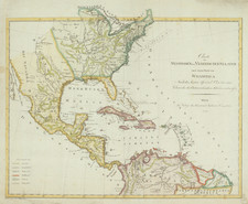
![[ First Map to Name The United States ] L'Amerique septentrionale ou se remarquent les Etats Unis . . . 1779](https://storage.googleapis.com/raremaps/img/small/94192.jpg)