


|
||

|

|
|

|
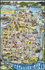
Rare pictorial map of the area above Los Gatos and the Lexington Reservoir near Bear Creek Redwood Reserve, published for the Montezuma Mountain School For Boys and drawn by Ruth Taylor White.
As noted on the Cornell / Persuasive Maps: PJ Mode Collection listing for this map
This is a promotional map for the Montezuma Mountain School for Boys, a prep school "that drew children of the rich and famous to a remote corner of the Santa Cruz Mountains" in northern California from 1910 to 1955 . . . The map is dense with pictorial elements showing happy boys engaged in a vast range of activities, with an emphasis on outdoor and athletic events.
The school was founded and run by Professor Ernest Rogers, "an educational pioneer" whose "avant-guarde theories" included rigorous chores for the 150 students, the study of Esperanto, and extensive "legislative-style debates" in a student government organization he also founded, the Junior Statesmen of America. . . . The campus, on 264 acres above what we now call Silicon Valley, included a fishing pond, dairy, horses, orchard and cannery. In the 1930s, when this map was made, the school excelled both academically and in sports. Ibid. The core of the school's campus is now a conference and retreat center operated by The Sisters of the Presentation.
Ruth Taylor White . . . was well known for the cartoon-figure pictorial maps she produced from the late 1920s into the 1940s. She "depicted a nation and a world where cheerful characters flocked by railway, auto-mobile, ship and airplane to visit picturesque land-scapes full of colourful natives, iconic architecture and natural wonders. She wanted, as she put it, to ‘make geography painless’ for her viewers.". . .
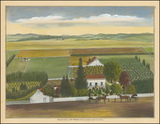
![[ Washington Township / Murray Township ] Res. & Stock of J.T. Walker, Washington on Corners & Residence and Farm of Christian Knittel, Murray Tp, Alameda County, California](https://storage.googleapis.com/raremaps/img/small/102042.jpg)
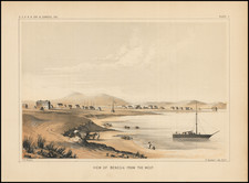
![[ San Francisco Bay and Approaches ] Chart of the Farallones and Entrance to the Bay of San Francisco... 1850](https://storage.googleapis.com/raremaps/img/small/98405.jpg)