![(Fools Cap) Afbeeldinge van't zeer vermaarde Eiland Geks-Kop [Picture of the Highly Renowned Island of Fools Cap, Situated in the Sea of Shares, Discovered by Mr. Lau-rens.] By Anonymous](https://storage.googleapis.com/raremaps/img/small/104266.jpg)


|
||

|

|
|

|
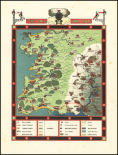
The Fools Cap -- An Iconic Satirical Image of the Mississippi Bubble Scheme
A map of the island of Geks-Kop (fools cap) from Het Groote Tafereel Der Dwaasheid (The Great Mirror Of Folly).
Iconic example of imaginary cartography satirizing the results of the so-called Mississippi Bubble, certainly one of the most famous cartographic curiosities. The image provides a comic representation of the collapse of the French Compagnie de la Louisiane d'Occident (French Company of the West), founded by the Scottish financier John Law in 1717. The Company was granted control of Louisiana, selling massive numbers of shares to the French public to finance its plan to exploit the resources of the region (the 'Mississippi Scheme'). The scheme resulted in wild speculation and people rushed to invest: share prices opened at 500 livres, but rapidly rose to 18,000 livres. Once speculators began serious profit-taking, the share prices and public confidence collapsed and the company quickly failed, ruining many, not only in France, but throughout Europe and nearly bankrupting the French Government. As a consequence of this failure, confidence in many colonial schemes collapsed, forcing many companies into bankruptcy, including the English South Sea Company and a number in the Netherlands, prompting this satire.
The title translates as:
A representation of the very famous island of Mad-head, lying in the sea of shares, discovered by Mr. Law-rens, and inhabited by a collection of all kinds of people, who are generally referred to as shareholders.
At the center of the image is a map of an island depicted as the head of a fool, with ears of a jackass, wearing his traditional cap; the place names include Blind Fort, Bubble River, and Mad House, surrounded by the islets of Poverty, Sorrow, and Despair. In fact this fine and detailed engraving makes several more references to speculative financial bubbles in the labeling of the various features of its fanciful cartography: Deceivers' Town (Bedriegers Stadt), Foolsburg (Sottenburg), Liarsburg (Leugenburg), Madhouse (Dollen Huyse), Noise Quarter (Raas wyk), and the like. Further, it depicts the consequences for the hapless investors, who bore the brunt of the failure, while at the same time exposing their greed and foolishness in believing the wild promises made on behalf of the various companies. In a vignette in the bottom left of the overall image can be seen Quinquempoix Besieged, which shows the headquarters of John Law's French Company, located on Rue Quimquempoix, being stormed by a mob of angry investors. In another hilarious vignette, whose title translates as Flight of the Inhabitants of Madhead Island, one can observe a distraught investor fleeing his angry creditors in a sort of land-yacht, or ship with wheels, flying a flag saying "To Viane," which is a reference to a "free city" during the Middle Ages, a place of sanctuary from creditors. Above the two scenes are smaller vignettes of a man near an empty treasure chest and in the other a man weeps on a street.
A pair of allegorical figures are incorporated into the elaborately printed frame surrounding the map: an owl, with the motto Ik Bemin De Duysternis (I like darkness), and a cat, with the motto By Nacht soek Ik myn Fortuyn (I seek my fortune by night). Above the map is shown T Waapen Van Dit Eyland (The Arms of this Island) – a share certificate, dated 1720, which is shown being blown about by the five winds, symbolizing the worthlessness of the certificate in the winds of fortune.
The print, Afbeeldinge van't zeer vermaarde Eiland Geks-Kop, gelegen in de Actie-zé (Picture of the Very Famous Island of Madhead, Situated in the Sea of Shares)... satirizes both the "actionists" who inhabit this fool's island and the very cartographic forms that induce investors to go in for these quasirational, pseudoscientific projects in the first place. This sort of fabulous cartography had a long and illustrious early modern pedigree. The Madhead map bears a striking resemblance, for example, to the woodcut used in Thomas More's Utopia, meant to depict an imaginary island - Benjamin Schmidt, "The Folly of the World: Moralism, Globalism, and the Business of Geography in the Early Enlightenment" in: The Great Mirror of Folly: Finance, Culture, and the Crash of 1720 (2013), page 256.
Perhaps the most iconic of all images of the Mississippi Bubble, and a key item for any collection of imaginary cartography.
![Comparative Size of Lakes and Islands [Great Lakes, Cuba, Formosa, Ireland, Sicily, Cyprus, Vancouver, Sandwich Islands, Puerto Rico, Corsica, Sardinia, Balearics, Malta, etc]](https://storage.googleapis.com/raremaps/img/small/100135.jpg)
![[Illuminated World Map -- There is no region of the world which Jesus, like the sun, does not enrich...] Orbis nulla plaga est quam sol non ditet Iesus...](https://storage.googleapis.com/raremaps/img/small/62347.jpg)
![[Pictish Man Holding Sword and Pike] Alterius viri Pictis vicini icon IIII](https://storage.googleapis.com/raremaps/img/small/99890.jpg)
![[ American Antiquarian Society Membership Certificate -- Charles Lucien Bonaparte, Prince of Canino and Musignano ] Olim Meminisse Juvabit](https://storage.googleapis.com/raremaps/img/small/84482.jpg)