|
||

|

|
|

|
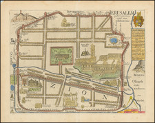
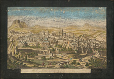
Jerusalem, Mapped by "the first amongst German geographers" (Ernst Georg Ravenstein, Fellow of the RGS).
Scarce, separately published map of ancient Jerusalem and its surroundings, published during the great push for the scientific remapping of the Holy Land in the middle of the 19th century. This map was published by Heinrich Kiepert in Berlin in 1845, following information from a variety of sources, including the first Robinson expedition to the Holy Land, and research by Dr. Ernst Gustav Schultz, the Prussian consul for Jerusalem. This map was part of the reason why Karl Ritter, the "father of modern geography," wrote that Kiepert's remapping of Palestine:
"was accomplished by H. Kiepert in so masterly a manner and in every respect so thoroughly scientific a spirit, as to win the applause of all scientific judges and to be the model for all following works of its kind."
The map is extremely detailed in the German scientific style of the 19th century. The layout of streets, plazas, and churches are shown in red for the old city, while the new city is mapped but not shown. Points of interest are shown, including the Jewish, Christian, Muslim, and Armenian Quarters. The extensive compound of the Temple of Solomon, now converted into a mosque, is shown in the eastern part of the city. Overlooking the city are the hills of Jerusalem, with many road leading in and out of the city. The old fortifications are shown in red, while the new fortifications, slightly further out, are lightly shaded.
At the base of the map is an elevational cross-section through the city, with the temple compound, bridges, and other features shown. An extensive legend and key to the map appears in the lower right of the map.
Heinrich Kiepert and the Mapping of Palestine
Heinrich Kiepert was one of the leading German cartographers of his time, and specialized in the mapping of the Holy Land. He was first exposed to this subject at the end of the 1830s, when Karl Ritter suggested him as the cartographic correspondent to the first Robinson and Smith expedition. Despite the success of the Robinson and Smith expedition, Kiepert's involvement was less notable. As his first major cartographic assignment, he was unprepared for the task and left Robinson disappointed, and he was replaced early on.
However, Kiepert's mentor Karl Ritter continued to have faith in his student. Over the next decade, Kiepert accumulated more information regarding Jerusalem and Palestine, and his maps came to be viewed as the foremost authority on the subject. Thus, by the time Robinson returned to the region for his second expedition, he again chose Kiepert to map the results of the expedition. This time, his involvement was a success and allowed him to complete a definitive map of the region.
Rarity
We trace no examples of this map as having appeared on the market.
![[ Jerusalem ] Die Heilige Statt Jerusalem Contrafehtet nach Form und Gestalt wie sie Ietz Erbauwen ist](https://storage.googleapis.com/raremaps/img/small/88642.jpg)