|
||

|

|
|

|
Stock# 83334
Description
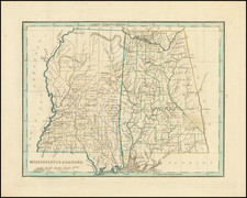
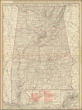
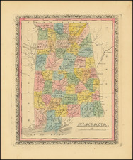
Rare German map of Alabama, published in Weimar.
The map shows numerous early oversized counties and Indian Lands, including a massive Upper Creek region on the Georgia Border, with Cherokee Lands above.
The western boundary with Mississippi includes Chocktaws Lands. The southeastern area on the Gulf Coast is called West Florida, but colored to show it as part of Alabama. Jackson's Route to New Orleans is shown, along with many early roads, towns, forts and other features.
![[Florida and Gulf Coast] The Coast of West Florida and Louisiana . . . [with] The Peninsula and Gulf of Florida or Channel of Bahama with the Bahama Islands . . .](https://storage.googleapis.com/raremaps/img/small/66344.jpg)