|
||

|

|
|

|
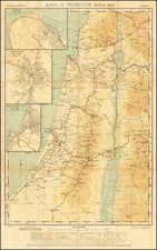
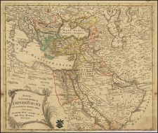
Rare Medieval Map of the Levant by Pietro Vesconte
This interesting map of the Levant represents the earliest printed record of a manuscript drawn by Pietro Vesconte, which was presented to Pope John XXII by Marino Sanudo Torsello in 1321, as part of a grand proposal for a new cruade.
Oriented with East at the top, this remarkable medieval map of the Levant extends from Turkey to Mecca and Cairo, and includes a fine early depiction of Medieval Cyprus. The original manuscript map was drawn by Pietro Vesconte sometime between 1318 and 1321. Vesconte was the premier Portolan chartmaker in Venice between about 1310 and 1330, and was the author of the earliest known surviving Portolan chart of the Mediterranean which is signed and dated.
The map appeared in Bongars' Orientalium expeditionum historia. Gesta Dei per Francos, sive Orientalium expeditionum, et regni Francorum Hierosolimitani historia (Hanau, 1611). Bongars (1554–1612) was one of the best regarded chroniclers of then surviving medieval texts, iincluding important works dating to the crusades. During his lifetime, he ammassed over 500 manuscript works.
The present map is the earliest surviving printed example of the map of the Levant drawn by Pietro Vesconte for Marino Sanudo Torsello's Liber secretorum fidelium crucis (Book of Secrets of the Faithful of the Cross), prepared in 1321. Sanudo, a Venetian merchant and stateman, presented the work to Pope John XXII, in order to promote a new Crusade to the Holy Land to take back the lands conquered by the Mamaluk rulers of Egypt following the Siege of Acre in 1291.
Pietro Vesconte was a Genoese cartographer and geographer, who was one of the most important and influential makers of Portolan charts. His map of the Levant combines the style of the medieval portolan maps in its treatment of the Eastern Mediterranean, with a stylized medieval depicition of the lands between the coast, Mecca and the Tigris and Euphrates rivers. As noted in the abstract to the workd of Stefan Schroeder:
The design of [Vesconte's] . . . differs considerably from other contemporary maps, such as the mappae mundi of Ebstorf and Hereford or the so-called ‘situs maps’ that present an idealised depiction of the city of Jerusalem. In total, the maps seem to focus on the transmission of geographic rather than religious knowledge, thus conveying the impression of a more ‘accurate’ view of the physical reality. As a consequence, they have been interpreted as marking the beginning of a new phase in the history of cartography that led towards modern practices of map-making. [However, Schoeder concluded that] . . .Vesconte’s maps do not represent a fundamental change concerning religious aspects in the perception of the world, [but instead are the result of a focus on geography] . . . from the use of Arabic- Islamic templates as well as techniques that characterise Portolan charts. Taken together, both features allowed the reader of Sanudo’s text to better visualise the author’s complex [crusadee] plan. Nevertheless, they did not diminish the maps’ potential to make it possible to contemplate God’s creation and to follow salvation history, an essential function of pre-modern maps. . . some elements of the maps even introduced new details of religious knowledge.
Rarity
The map is scarce on the market.
AMPR lists only 3 examples in dealer cataloges in the past 30 years.
Schroeder: Religious Knowledge within Changing Cartographical Worldviews Spatial Concepts and Functions of Maps in Marino Sanudo’s ‘Liber secretorum fidelium crucis’ (c. 1321)
Jacques Bongars, Seigneur de Bauldry et de La Chesnaye, was a French diplomat and classical scholar who compiled a history of the Crusades.
A Huguenot, Bongars studied in Germany, Italy, and Constantinople. From 1586 Henry of Navarre (later King Henry IV of France) sent him on missions to obtain men and money from the German princes and from Queen Elizabeth I of England. As French minister in Germany (1593–1610) he tried to unite Protestant princes in a league with King James I of England at its head.
Bongars published an annotated edition of the Roman historian Justin’s works in 1581 and a French translation of the letters of Aristaenetus in 1597. He was interested, however, not only in ancient writings but also in medieval chronicles. His collection of historical works on Hungary (1600) was followed, in 1611, by the far more important Gesta Dei per Francos (“God’s Work Through the Franks”), a collection of contemporary accounts of the Crusades. An edition of his letters, in Latin, appeared in 1647, a French translation in 1668–70. His diary of his journey to Constantinople was printed in 1874.
Pietro Vesconte was a fourteenth-century mapmaker best known for his pioneering portolan charts. Born in Genoa, he performed the bulk of his work in Venice between 1310 and 1330.
While portolan charts are known to have existed since at least the thirteenth century, Vesconte significantly improved on the form and produced highly-accurate charts of the Mediterranean, the Black Sea, and Northern Europe. His 1311 chart of the eastern Mediterranean is the oldest signed and dated nautical chart. He also made at least four signed atlases. One of these, a 1318 atlas, includes an image of a chartmaker at work which is likely Vesconte. The cartographer also made several maps, including a distinctive mappa mundi included in Marino Sanuto’s Liber secretorum fidelium crucis.
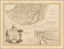
![[ Tribes of Zabulun Issachar, Manasseh ] Tribus Zabulon, Isachar, et, Dimidia Manasse altera, hoc est illae Terrae Sanctae regiones . . .](https://storage.googleapis.com/raremaps/img/small/95602.jpg)