


|
||

|

|
|

|
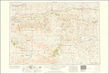
An Important Map of Nebraska Territory
Fascinating map of Nebraska Territory, including the modern states of Montana, Wyoming, Colorado, North Dakota, South Dakota, Kansas, Iowa and Missouri, drawn from material compiled by Lieutenant Gouverneur Kemble Warren.
This is the first of Warren's maps, which would be followed by his General Map of the Explorations and Surveys . . . 1857, the first map in the so-called Warren-Freyhold series which would span nearly 30 years and illustrate in over a dozen different editions the ever improving surveying and reconnaissance in America's Transmississippi Western United States.
This first map incorporates the explorations of a number of important surveys, including:
- Stephen Long (1820)
- J.N. Nicollett (1839)
- John C. Fremont (1842-43)
- Howard Stansbury (1849)
- Paul Carrey (1853)
- G.K. Warren (1855)
- Gen. Harney (1855)
GK Warren made 3 expeditions through the Nebraska Territory in the 1850s. His 1855 trip was made as chief topographical officer in Gen. Harney's expedition against the Sioux. Led by General William S. Harney, the mission was a punitive expedition against the Sioux, following the killing of a small US Army detachment in Nebraska Territory, an event called the Grattan Massacre.
Beginning in 1853, Warren assisted in a government study to determine the best possible transcontinental railroad route, examining reports of all explorations west of the Mississippi, dating back to explorations of Lewis and Clark. As part of this analysis, Warren began work on the first comprehensive map of the Trans-Mississippi West.
In 1855, Warren served as chief topographical officer in General William S. Harney's expedition against the Sioux in southern Nebraska Territory (in present-day Nebraska and South Dakota). His topographical report earned him great recognition and command of future explorations. In 1856 Warren commanded a successful survey mission in northern Nebraska Territory along the Missouri River and 60 miles up the Yellowstone.
Warren spent a year in Washington after his 3 expeditions, compiling his findings into official reports and completing his Map of the United States from the Mississippi to the Pacific Ocean, which accompanied Secretary of War Jefferson Davis' final report to Congress on the results of the transcontinental railroad route investigation.
Rarity
The map is scarce. This is the second example of the map we have had in more than 25 years.
![Rand, McNally & Co's Nebraska [Rand, McNally & Co's Indexed Township and County Pocket Map and Shippers' Guide of Nebraska]](https://storage.googleapis.com/raremaps/img/small/85065.jpg)
![(Colorado Springs Photograph) [Original cabinet card albumen photograph of Tejon Street, Colorado Springs, looking south toward Cheyenne Mountain]](https://storage.googleapis.com/raremaps/img/small/87515.jpg)
![(Civil War) Fredericksburg … [with] Map… of the Sioux Expedition [with] Map of the Fight of the 14th A.C. Buzzard Roost, GA [and ] Big Mound [and] Dead Buffalo Lake [and] Dry Fort Creek](https://storage.googleapis.com/raremaps/img/small/97072.jpg)