


|
||

|

|
|

|
Stock# 82530
Description
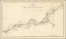
Detailed map of the area around the Hacienda El Carmen, north of the town of Tehuacán, in the State of Puebla, in central Mexico.
The map extends north to the area of San Jose Ixtapa.
The map includes topographical details, including elevation contour lines, mesas, creeks, etc., along with roads and what appears to be a train line.
There are 3 Ejido's separately colored, in addition to the Hacienda El Carmen, with the boundaries of the numerous pueblos shown.
Condition Description
On onionskin.

![[ Southwest & Texas ] Le Nouveau Mexique, Avec La Partie Septentrionale De L'Ancien, ou De La Nouvelle Espagne](https://storage.googleapis.com/raremaps/img/small/99395.jpg)

![Ferrocarril de Mexico á Toluca y Cuatitlan Plano Topografico del terreno explorado entre Mexico y Toluca, con las diversas lineas estudiadas para el trazo de la via. Levantado y Dibujado por disposicion del Sr. Mariano Rivapalacio. [Railroad from Mexico [City] to Toluca and Cuatitlan. Topographic map of the terrain explored between Mexico and Toluca, with the various lines studied for the route layout. Surveyed and drawn by order of Mr. Mariano Rivapalacio.]](https://storage.googleapis.com/raremaps/img/small/88860.jpg)