|
||

|

|
|

|
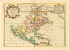
Attractive full color example of Quad's map of North America, based upon De Jode's map of 1593, the first to incorporate the discoveries of John White & Jacques LeMoyne along the east coast. Virginia's nomenclature is too far North. An inviting Northwest passage invites a simple route to the Pacific. A curious second Peninsula is shown west of Florida, perhaps an early appearance of the Mississippi Delta. The descriptive text below provides a brief overview of the history of North America to date. The projection of California and the West is packed full of annotations and place names. The headwaters of the St. Lawrence extend to Cibola in the mythical Southwest. A cornerstone collector's map of North America. Burden 133; Cumming 24.
Matthias Quad (1557-1613), a map publisher based in Cologne, was trained in the Netherlands by Johannes van Doetecum, who also worked with the De Jodes. Quad used many De Jode maps as a base to which he added additional information and decorations. Quad was best known for his atlases, which were part of the first boom in atlases best characterized by Abraham Ortelius’ Theatrum Orbis Terrarum. In 1592, Quad released an atlas of Europe that had 38 maps. He expanded it in 1594 to 50 maps. In 1600, he expanded the collection of maps further still, this time to 82 maps, and called the atlas, Geographisch Handtbuch. All three were small in size, allowing them to compete as cheaper alternatives to the larger atlases of Ortelius, Mercator, and the De Jodes. Quad released one other atlas, in 1608, with 86 maps, the Fascilus Geographicus.
![Navigatio ac Itinerarium Iohannis Hugonis Linscotani in Orientalem Sive Lusitanorum Indiam... [Voyage and Journey of Jan Huygen van Linschoten to the Eastern, or Portuguese India...]](https://storage.googleapis.com/raremaps/img/small/93009.jpg)