|
||

|

|
|

|
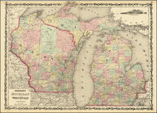
Gorgeous example of this early map of Wisconsin, issued in 4 years prior to statehood.
This 1844 edition is the first appearance of Richland County, which was founded on February 18, 1842.
The lands south of the Wisconsin and Fox Rivers are largely surveyed and many early counties, towns, etc. appear. The region to the north is dominated a massive Crawford County and St. Croix Counties. Brown. Portage, Chipewa and Lapoint are not yet established. These lands of the Winnebagos, Menomonies, Oneidas, Sioux New York and Chippewa Indians are shown prominently. Massive Carver claim remains, now nearly 100 years old.
The south is filled with roads, and towns, the north rivers, portages, etc. One of the best early maps of Wisconsin in full original color.


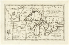
![[ Great Lakes - Upper Midwest -- Western Canada ] Partie Occidentale Du Canada, contenant les cinq Grands Lacs, avec Pays Circonvoisons](https://storage.googleapis.com/raremaps/img/small/98377.jpg)