|
||

|

|
|

|
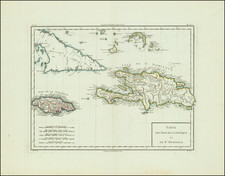
Sailing the Gulf of Mexico at the End of the Eighteenth Century
Fine late-colonial chart of the Gulf of Mexico produced with input from chronometers held on the San Lorenzo.
The general chart encompasses the Yucatan Peninsula and the Mexican Coast, arcing to Louisiana and Florida. The Caribbean portion includes Cuba, the Bahamas, and Jamaica. The chart has rhumb lines for plotting a course and a striking compass rose. Sounding depths and navigational obstructions are clearly marked, to help a navigator plan his voyage.
The chart was most likely made by an officer or a naval engineer on active duty in the Caribbean. It is dated 1799, which falls within a period of renewed hydrographic activity by the Spanish Navy. After the cessation of the Anglo-Spanish War, Spain sought to refine its existing cartographic archive. The campaign included a new survey of the coasts of the Iberian Peninsula (1783-1787), the Malaspina expedition (1789-1794), and the Atlas de la América septentrional project led by Cosme de Churraca (1792-1805). This chart was possibly part of the latter effort, which re-charted the Gulf of Mexico at a higher resolution than ever before.
The San Lorenzo
The chart is an impressive survival, but the ship that contributed to its making was also important. The San Lorenzo was a third-rate Spanish ship-of-the-line. It was ordered in 1763, purpose-built for the Spanish Navy, and launched in 1768. The ship was designed to carry a complement of 450 crew and had 74 guns.
The ship spent most of its working life in the Caribbean. In the mid-1790s the ship served as a galleon, sometimes carrying as much as 15,000,000 pesos. In 1796, the ship transported Christopher Columbus’ body from Santo Domingo to Havana, Cuba.
In 1799, when this chart was made, the San Lorenzo was stationed at Havana. The ship was sunk there in 1815; it had become ineffective due to lack of careening.
John Arnold and his chronometers
The chart was corrected, according to the title, from Arnold’s chronometers, numbers 154 and 349. John Arnold (1735/6-1799) was a watch and chronometer maker originally from Bodmin, Cornwall. Arnold trained with his father, also a clockmaker, and his uncle, a gunsmith, before seeking more instruction in the Netherlands. He set up shop in London in 1762 and was introduced to the British Court in 1764.
Arnold turned to marine clocks in 1767. He provided three for testing on James Cook’s second voyage, but they did not perform well. Arnold improved on his design and simplified it, making it more affordable to officers and other buyers. Arnold patented the helical spring, terminal curves, and a compensation balance. His watch 36 used such a balance and impressed the astronomers at the Royal Observatory, Greenwich. Arnold was supported by Alexander Dalrymple, who published an account of the trial of watch 36 in which he explains that he and Arnold had created a new word—chronometer, the first use of the term in its modern sense.
By the mid-1780s, Arnold had a reputation as one of Britain’s foremost manufacturers of marine clocks. His clients included the British Admiralty, the English East India Company, and the Spanish Navy. His son, John Roger Arnold, entered into partnership with his father in 1783 and John Jr. continued the business after his father’s death in 1799.
Provenance
Sothebys lot 164, sold on June 21, 1990; Group lot, including two manuscript charts and four printed charts.
![[ US-Mexico Border Survey: General Order From the President of the United States Directing William H. Emory to lead the US-Mexico Boundary Survey ]](https://storage.googleapis.com/raremaps/img/small/101837.jpg)
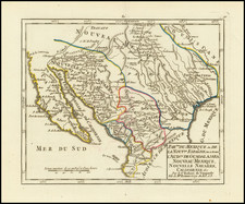
![Map of Texas [with] inset of N.W. Part of Texas](https://storage.googleapis.com/raremaps/img/small/84519.jpg)