


|
||

|

|
|

|
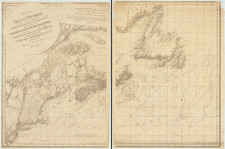
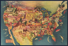
Early Portolan Chart Documenting Jacques Cartier's Discoveries in Canada
Finely-preserved portolan chart of the east coast of North America, from Newfoundland to the Caribbean and the Gulf Coast, which seemingly corresponds to works by (and attributed to) the famed 16th-century Portuguese geographer and cosmographer Bartolomeu Velho.
The chart is a rich record of mid-16th-century geography and toponymy from Texas through Florida and up the entire present-day U.S. East Coast. In Canada, it is an exceptional through-link positioned between the Cartier expeditions of the 1530s and '40s and Champlain's explorations at the beginning of the following century. The chart's provenance is well-attested, having been discovered in 1961 in a 17th-century English binding in Sussex and recorded shortly thereafter in Armando Cortesão and Avelino Teixerada Mota's tour de force monograph Portugaliae Monumenta Cartographica (1960-62, see Volume V, pages 7-9).
This exceptional artifact is one of the earliest surviving maps to depict the discoveries Jacques Cartier made during his first and second voyages to Canada (1534-36). While no original Cartier maps are known to have survived, by the late 1540s, the information derived from Cartier's voyages began to appear on Portuguese portolan charts, of which several survive to modern times. As discussed at greater length below, the charts by and attributed to Bartolomeu Velho are among the most accurate of these Cartier-derived mappings. In his seminal work on the early mapping of Canada, W.F. Ganong described Velho's work as the most likely of the Portuguese portolans to have been created directly from no-longer-extant original Cartier sources.
The present chart, drawn on vellum, is the upper-left quadrant of a larger sheet, for which the lower-left section is also known to survive in the Rye Castle Museum in Sussex, England (see discussion below). While many place names and details can be seen on the chart, we also include in this description a multispectral image. The multispectral image reveals details and toponyms which are not otherwise legible.
Stylistically, the present chart is strikingly similar to the hand-drawn portolan charts by or attributed to Bartolemeu Velho, including most notably (1) a four-sheet world map of 1561 held by the Istituto e Museo di Storia della Scienza (better known as the Medici Museo Galileo in Florence), (2) a 1561 chart held by the BnF, and (3) a Velho-attributed portolan atlas held by the Huntington Library. All surviving Velho and Velho attributed charts are dated to about 1560 to 1568, making them among the earliest surviving depictions of Jacques Cartier's expeditions. Moreover, only the present example and the Medici Museo Galileo example (likely commissioned by Cosimo Medici) include the details from Cartier's second voyage, along with a map made by Vehlo for King Sebastian of Portugal (1554-1578) and an illuminated cosmographical treatise made for King Charles IX of France (1550-1574).
The story of the present chart, while impossible to know with perfect accuracy, reveals that it is one of only a small group of surviving portolan charts to depict the east coast of North America, during the period of the 16th Century when Portolan charts were still the most advanced means of depicting new discoveries and the most advanced cartographic knowledge of the New World. This point is well illustrated by comparing the cartographic content of the present chart to the most important printed maps of the period, such as the 1562 Diego Gutierrez 6-sheet map of America. With respect to the discoveries of Jacques Cartier, it would not be until Gerard Mercator's 1569 wall of the world and Abraham Ortelius' map of America of 1570 that a meaningful depiction of Cartier's discoveries would be widely disseminated in a recognizable form, with the first regional (i.e., enlarged) depictions of Cartier's discoveries not appearing on printed maps until Cornelis Claesz's Nova Francia (circa 1594).
The chart also conceals at least one great mystery, the placement of the national flag of the Duchy of Brittany on Cape Breton. Was this the chartmaker's tribute to the Breton-born Cartier, a tribute to an unrecorded Breton sponsor or some other partially known bit of history? Even the discovery and earliest voyages to the region are a bit opaque, with historians lamenting the lack of surviving documentation of the early Breton and Portuguese contacts with the region.
Early Exploration of French Canada and the St. Lawrence
The recorded exploration of Canada began shortly after Columbus. The Canadian coastline, and specifically Cape Breton, had been reached by John Cabot in 1497, and the southern entrance to the Gulf of St. Lawrence was likely reached by Portuguese explorer Joam Alvarez Fagundes in 1520-1521 or earlier. However, prior to 1534, no recorded explorations had been conducted into the Gulf of St. Lawrence or the St. Lawrence River. Accordingly, the region remained uncharted by European mapmakers.
The first recorded explorations in the St. Lawrence region were undertaken during the three voyages led by Jacques Cartier between 1534 and 1542. Cartier (1491-1557), a French-Breton from St. Malo, initially explored the Gulf of St. Lawrence and reached Anticosti Island during his first voyage (1534). In his second voyage (1535-1536), he sailed beyond Anticosti Island into the lower part of the St. Lawrence River, reaching the Iriquois village of Stadacona (Quebec City), then proceeding further upriver by longboat to Hochelaga, the modern-day location of Montreal. Cartier's explorations are also credited with giving the name "Canada" to the region. Cartier's third and final voyage (1541-42) would be better outfitted, but would not add significantly to the region explored in the second voyage.
Curiously, it would be another fifty years before the French would again visit the St. Lawrence River. In 1599, the merchant François Gravé Du Pont and French Royal Navy Captain Pierre de Chauvin de Tonnetuit founded a fur trading post at Tadoussac. Du Pont's nephew, Samuel de Champlain, accompanied Du Pont on his trading venture and would go on to write the next chapter of the exploration of the region in the first decades of the 17th century.
Mapping The Discoveries of Jacques Cartier
No original maps, drawings, or other iconographic images survive from any of the three Cartier voyages. There is no contemporary printed account of Cartier's first voyage, although a nearly contemporary manuscript exists at the BnF, which was published (Relation Originale. . .) in 1867. Three early manuscript accounts of the second voyage exist (all at the BnF). The first printed account of Cartier's second voyage was published in 1545 in Paris (Brief Recit, & . . . ), with translations into Italian by Ramusio (Naviganti tet Viaggi . . ) in 1565 and into English by John Florio (A Shorte and Briefe narration. . .) in 1580. For the third voyage, a single incomplete manuscript account survives, which was translated into English and printed in 1600 by Hakluyt.
While Cartier's expeditions left no maps which survive to modern times, there is surviving correspondence indicating that in 1539, the King of France possessed two charts, "well painted and illuminated," which Ganong noted were drawn directly from Cartier's explorations. In the later part of the century, Cartier's nephew makes several references to maps drawn by Cartier still in the possession of the family or family associates.
Hints of the Gulf of St. Lawrence and St. Lawerence River began appearing on maps as early as Sebastian Munster's 1540 map of America, which shows a large river west of the island "Corterati" (almost certainly Newfoundland, discovered by Gaspar Corte-Real). The earliest known manuscript chart of the Gulf of St. Lawrence and the St. Lawrence River is an anonymous Spanish map that has been dated to circa 1541. The map is based on Cartier's voyages and includes villages named "breton" and "canada."
The first clear integration of Cartier's discoveries in a broader context appears on António Pereira's chart (circa 1545), the anonymous "Harlaein Chart" (circa 1546), and on a chart in the Vallard Atlas (circa 1547). However, the discovery of the St. Lawerence River was either ignored or unknown to virtually all of the most prolific chartmakers of the period, such as Battista Agnese and Francesco Ghisolfi, even into the late 1560s. Even up to the 1560s, only a few chartmakers were able to integrate a credible depiction of Cartier's mapping of the St. Lawrence River. See, for example:
- Pereira, ca. 1545.
- Harleian Chart ca. 1546
- Descelirers 1546
- Vallard, 1547
- Giorgio Sideri (Calapoda) 1550
- Pierre Desceliers 1550
- [Diogo Homem] ca. 1558
- Diogo Homem 1558.
- Vehlo 1561
- Diogo Homem ca. 1565
Even famed chartmakers such as Sebastião Lopes and Battista Agnese were still not integrating the information at the end of the 1550s and early 1560s:
Bartolomeu Velho attribution
Bartolomeu Velho (? - 1568) was a Portuguese mapmaker, geographer, and cosmographer active in Lisbon and later Nantes. Wigen, et al., write that Velho was "the founder of the leading school of mapmaking in Portugal [and] has been identified as a Jew from Majorca named Jacome . . . [whose mapmaking] skills and know-how related to navigation . . . had all advanced under the influence of Jewish or converso . . families." He is perhaps best known for his Carta General do Orbe, made for Sebastian of Portugal in 1561 and his magnificent illuminated Principio da verdadeira cosmographia . . ., made for King Charles IX in 1568.
Within Portuguese mapmaking circles, Velho's work was clearly well informed, with early access to newest discoveries in Asia, Africa and the New World. For example, Velho was the first Portuguese mapmaker to chart California. Velho's chart of 1561 maintained the concept of Brazil as an island and was the first to feature the subdivision of the territories into captaincies. His mapping of Africa was considered a significant advancement (Alegria, p 1000-32). Fiorani notes that Cosimo Medici provided famed Italian artist Ignatio Danti with "the nautical charts made by Bartolomeo Velho in 1561, from which [Danti] copied the coastline of southern Africa, the East Indies and South America" for Danti's monumental maps in the Palazzo Vecchio in Florence, which are still on display in the Sala di Guardaroba. This is almost certainly the example which still survives in the Medici Museo Galileo.
Velho was clearly far more than simply a maker of portolan charts, as the following two worlds (both of which include Cartier's discoveries) illustrate:
- 1568: Manuscript Map of the World from Velho's Principio da verdadeira cosmographia e geographia unniversal de todas as terras. (acquired in 1950 by the BnF)
- 1560: Map of the World in 24 gores made for King Sebastian of Portugal (BnF).
By the mid-1560s, Velho appears to have been actively recruited by Andre d'Albaigne and Francisque d'Albaigne to move to France, as part of the d'Albaigne brothers' project to promote a new voyage of discovery to the King of France. By 1567, Velho was living in Nantes. The move seems to have been a signficant event, as the French Ambassador to the Court of Madrid, Fourquevaux, wrote on September 30, 1567, that Velho's flight resulted in the Cardinal of Portugal ordering the arrest of André d'Albaigne, who was involved in Velho's departure (Bulletin Hispanique, pp 318-19). Cortesao opined that, "the Spanish or Portuguese court, concerned that the mapmaker [might] disclose secret information about discoveries in Asia, arranged to have him disposed of," because Velho "wrote that he had secret information about three thousand leagues of coat rich with gold and silver" (Simonova-Gudzenko, p. 138). By contrast, Wigen states that he moved to Nantes to flee the Portuguese Inquisition, where the King of France was able to obtain from him "confidential geographical knowledge."
The d'Albaigne brothers were actively lobbying the King to authorize a French-sponsored voyage to a “certain very rich new land of very great extent not yet discovered by the kings of Spain and Portugal,” and had recruited Velho from the service of the Portuguese to “demonstrate” to King Charles IX the location of this unknown country. Several items of correspondence from 1566 and 1567 corroborate Velho's name being used in the promotion of the venture, and his surviving output while in France corroborates a relationship with the King of France.
Velho's Principio da verdadeira cosmographia . . . , a remarkable illuminated masterpiece dedicated but never delivered to King Charles IX, bears witness to Velho's skills and importance in the d'Albaigne brothers's plans. The Velho Cosmography would instead be passed to Giovanni Andreozzi, patrician of Lucca, who in 1576 offered it to the Grand Duke Francis of Tuscany. At the end of the 19th century, it was discovered in the library of M. Ferreira das Neves, a Portuguese bibliophile, by Sousa Viterbo, by whom it was recorded and studied in 1890. The Cosmography reappeared in the library of Ch. Chadenat, at which time it was sold to the Bibliotheque Nationale de France on March 13, 1950.
Breton flag near modern-day Cape Breton and Velho's Breton connection
One prominent feature of the present chart is the large flag extending westward from the east coast of today's Cape Breton Island. The flag is that of the Duchy of Brittany. The Duchy of Brittany was an independent crown until 1532 (two years before Cartier's first voyage), when it merged with France. However, the merger came with the arrangement (the Ancien Régime) that the Duchy of Brittany would continue to be governed as a separate country. Its aristocrats were treated as foreign princes in the French royal court.
The area in question was likely visited by John Cabot in 1497, with Breton fishermen plying the waters consistently by 1520. In about 1521–22, the Portuguese under João Álvares Fagundes established a short-lived fishing colony on the island, but it failed within a few years. The Breton flag is also shown in the same region on the Girolamo Verrazano map of 1529, but not thereafter.
Velho's connections to the region, patronage, and the intrigue around his life (and possible murder) in Brittany remain shrouded in mystery.
Even before Velho moved to Nantes in 1567, he likely had contacts in Brittany. Portuguese Jews enjoyed varying degrees of trading rights in Brittany since the early-fifteenth century. As the repression of crypto Jews intensified in Portugal with the start of the Inquisition in 1536 and the first Portuguese autodafé in 1540, Portuguese Jews began an exodus to areas including Brittany. Henri II of France issued letters of authorization in August 1550, allowing merchants and other Portuguese New Christians to enjoy the same rights as Frenchmen. Large numbers of Marranos, secret Jews from Portugal, came to France in the mid-1500s.
Bartolomeu Velho's Charts
Approximately twenty Velho and Velho-attributed portolan charts and hand-drawn maps survive, most of which are unsigned and attributed to Velho (16 are contained in a single atlas at the Huntington Library). Only the Cosmography, the 1561 portolan in the Medici Museo Galileo, and the world map given to King Sebastian bear Velho's signature. Perhaps the most notable of these is the four-sheet chart of the world from 1561 held by the Medici Museo Galileo, which includes signficantly similar cartographic details and style, and bears a resemblance to the present chart in the sense that it treats the world in four overlapping horizontal sheets (the Pacific, America, Africa & Europe, Asia & Eastern Europe):
https://catalogo.museogalileo.it/oggetto/CarteNautiche.html
Other noteworthy Velho images include (dates based upon MEDEA dating):
- Huntington Library ca. 1560 [attributed to Batolomeu Velho]
- Huntingon Library ca. 1560 [attributed to Bartolomeu Velho]
- BnF [attributed to Bartolmeu Velho]
Dating The Portolan Chart
There is very little comparative data available to assist in the dating of the chart. Bartolemeu Velho's surviving output has been dated between 1560 and his death in February 1568. Of his surviving portolan charts to touch on the Gulf of St. Lawrence, only one (the Medici Museo Galileo example), shows the full extent of Cartier's explorations up the St. Lawrence River to Hochelaga. This example is signed by Velho and dated 1561. Both Velho's King Sebastian gores and the Cosmography also illustrate Cartier's discoveries of 1535-1536.
Cartographically, the Cartier details in the two charts are very similar, but there are also differences. The place names, additional detail, and the coastal contours on the Medici Museo Galileo chart, while generally similar to the present chart, are not identical. There are sufficient similarities to suggest a common precursor, but not enough to suggest primacy for one or the other or definitively confirm the Velho attribution.
The choice of different flag styles and the differences in the decorative and historical elements suggest a difference in the patronage or purpose between the two charts. Most surviving portolan charts from this period were made to order for specific wealthy patrons, as display or library objects intended to inform the most highly educated and noble classes. These were typically not tools of navigation. For example, the Medici Museo Galileo chart (in 4 sheets), is a compendium of the history of discovery, with references to Columbus and Magellan on this particular sheet. Even the location of important stars for celestial navigation are noted.
The present chart, which is not ornately adorned or illuminated, and lacks historical content, may in fact be an exception -- an example of a purely utilitarian chart intended for use at sea. The present chart is practical, as the four quadrants, re-imagined as a whole, would have covered the Atlantic to just south of the Tropic of Capricorn, encompassing what was then the classical navigable waters between Europe, Africa and the Americas, including the shortest northern and southern passages across the sea. The limited adornments, pragmatic depictions of the flags of the relevant naval powers claiming the regions shown, suggest a practical purpose.
Regional Comparison of the North American coastal charting of the Huntington and BnF Examples
Southeast Coast: On the BnF Chart, between Arenas (the prominent bulge believed in modern times to be Cape Hatteras) and the southern tip of Florida, there are eighteen place names (Joam to La Frolida), whereas there are 26 on the present map (Arenas to La Frolida). The Huntington Library map (46330 above), shows 25 placenames (Arenas to Florida (spelled correctly)). In addition to nearly identical spelling and orientations, even the habit of splitting a single word in a name into two lines is present.
Gulf Coast: On the BnF Chart, between b. de j ponce and Rio del Spiritu Santu, there are sixteen placenames, whereas there are twenty on the present map (Rio Del Spiritu Santu to b: de laguada -- not on the BnF chart). The Huntington Library map (46330 above), shows 22 placenames (io Del Spiritu Santu to b: de laguada).
Of further note for the Gulf Coast is the nearly identical placement, configuration, and number of islands, although both the BNF and Huntington charts include the "Martiles/Martilles" islands east of the Tortugas.
St. Brendan: One curious difference between the two charts is the placement of the mythical St. Brendan Island east of Newfoundland. The present chart places St. Brendan as the first island to the east of I: dalter, whereas the Huntington adds two other islands to the east and omits St. Brendan completely. The BnF Chart places it as the third island to the east, with the two islands shown on the Huntington chart shown to the west of St. Brendan.
Comparing the Medici Museo Galileo example
Because of the lack of a proper high resolution image to work with, toponym comparisons with the example at the Medici Museo Galileo proved difficult. We do recognize what appears to be a common mis-spelling of Florida (Frolida). St. Brendan is also shown as the third island east of Newfoundland, as with the BnF chart.
Southern fragment, Rye Castle, Sussex
Remarkably, another section from this same portolan has also survived. The southwestern quadrant of the chart is held in the Rye Castle Museum in Sussex, England. On July 1, 1961, the quadrant was brought to the attention of Cortesão and Mota, who described and included the section in Portugaliae Monumenta Cartographica, as plate 524 on pages 7-9 of Volume V. We have composited an image of that fragment with the northern half, which is shown as the third image in the gallery above. Cortesão and Mota provide an extensive description of the chart, as well as speculation on its authorship. Their physical description is worthy of excerpting here:
We learned recently that there is a fragment of a Portuguese chart in the Rye Museum, Sussex, and were shown a photograph of half of it. When, a few days later, we were able to see the fragment in the British Museum, we found that it formed the binding of a XVII-century English manuscript, from which it was subsequently separated.
The fragment, on parchment, simply illuminated, measures 370 x 497 mm and is not badly preserved, although most of the place names written in red are practically illegible [perhaps they meant "written in black, as is the case with our manuscript]. It must have been cut from a nautical chart, as shown by the fact that the central and southern parts of the American continent are not filled with the usual more or less fanciful drawings of contemporary cartography, and the ornamentation is very poor. We do not suppose that the fragment was cut from a planisphere; from a plain border drawn near its lower margin and the disposition of the remaining wind roses we may deduce that it was cut from the lower left-hand part of an Atlantic chart, of which the centre of construction was apparently situated not very far from the Cape Verde Archipelago.
Provenance
Sussex Record Office (per the aforementioned correspondence)
Sotheby's, June 25, 1992, lot 430.
The chart apparently has been cut from a larger chart and recovered from a binding. It seems to have some affinities with other known charts of this region, such as a chart in the Lazaro Luis atlas of 1563 (in the Lisbon Academia das Ciencias, illustrated in Cumming, Skelton and Quinn, fig. 75) in which landmarks are rendered in the Portuguese names given by Joao Alvares Fagundes in the 1520s, during which time the Portuguese also made unsuccessful attempts at establishing settlements on the Atlantic Seaboard. Although almost illegible, the place names in Florida appear also to predate the time of the first French colony there founded by Jean Ribaut in 1562.
Sawyer, purchaser of record from the above sale.
Private American Collection.
Toponyms, South to North
Multi-spectral imaging was undertaken by The Lazarus Project, University of Rochester, in 2022. The resulting images revealed dozens of toponyms that are illegible or nearly so on the map itself. The resulting image shows the chart possesses dense, rich toponymy worthy of further study. Here is a record of the toponyms on the North American coast.
Texas to Florida
baxos
R: demotanhas
c: de Jierlo
C: decruz
R: detesfrito Gaōto
ostial
c. marpe
quenlia
qutata[?]
matns de Saluadoz[?]
R: del canlia
vezal
R: de nieues
R: de fioles[?]
terra baxa
R: ctijo
b: degilt glꝫ [i.e., gonçalues?]
po hondo
costa de medanos
b: de magenlo
Peninsula of Florida
amcon baxo
los farelhones
b: de jo ponce
costa de carocoles
R. de buena pas
b: de laguada
la frolida [sic.? This seems to be an error, but it is repeated on BnF GE B-1148]
costa de fuegos
c: del canhaueral
c: de Sierto
C: de cruz
terra baxa
terra ilhana
East Coast, Georgia to North Carolina
C: giueso
R: de S: Ilena
playas ancones
R: Jordāo
c: des: Romāo
R: de canoas
terra ilhana
R: Seco
playa
po del paincepe
c: de trafalgar
R: de Stō espirito
b: de S: Ma
playas
c: de s: Jo
c: de las a[?]onas[?]
East Coast, Virginia to Penobscot
[?] santiague
R: de Sam Xpuāo [i.e., Saint Christopher]
R: de S: anto
mōtanha verde
R: de buena madre
b: de S: Juaō bautista
terra ilhana
c: de las baxas
arcepie laguo
c: de stā Ma de las muchas islaz
R: de las guamas [i.e., Penobscot Bay]
Penobscot, north to Canada
costa de medanas
golsaō
R: de mōtanhas
R: del casta nhalt[?]
playas
medanos
palmar
ba delaensea
R: de montans
b: baxa
c: delguado
playas
R: grande
b: Susa
R: do pracel
Ilheos chāos
b: de s: bernardo
Ilhas barcelonas
playa
R: verde
b: peq̃na
costa cusa
R: fundo
b chica
b: de santo antonio
c: dos britōes [this name is almost illegible and somewhat speculative]
de Sablo [Sable Island]
Newfoundland and Labrador
c: Raso
farelhō
I: despera
b: daconceicaō
I: dos bacalhaos
c: deboahta
I: de feiluis
I: dabes
I: dos cavalos
d roya[?]
I: degrat
bela Ilha
I: dalter
dafurtana
detron
S: Brandō [Saint Brendan's Island]
Cortesão: António Pereira and His Map of Circa 1545, Geographical Review , Apr., 1939, Vol. 29, No. 2, pp. 205-225.
Simonova-Gudzenko: Mapping Asia: Cartographic Encounters Between East and West (2018).
Kären Wigen, Sugimoto Fumiko, Cary Karacas: Cartographic Japan: A History in Maps (2016)
Alegria, et al., Portuguese Cartography in the Renaissance, The History of Cartography, Volume 3. Part 1 (2007).
Fiorani, The Marvel of Maps Art, Cartography and Politics in Renaissance Italy (2005).
Ganong: Crucial Maps - Part VI, The Voyages of Jacques Cartier (1934)
Bulletin Hispanique, Tome XV, Notes Sur L'Histoire de la Colonie Portugaise de Nantes, p. 316-339 (1913).
XXX Revue de Geographie, Vol 37 (1895)
Bartolomeu Velho (? - 1568) was a Portuguese cosmographer renowned across Europe for his cartographic skills and geographic erudition. Little is known of his family; he has been linked to a Jewish or converso background, and research suggests that his father was illuminator Diogo Fernandes. He is perhaps best known for his Carta General do Orbe, made for Sebastian I of Portugal in 1561, and his magnificent illuminated Principio da verdadeira cosmographia . . ., dedicated to King Charles IX of France in 1568.
However, he also produced numerous portolan charts and several world maps; the MEDEA database lists 24 charts and one atlas. His works were made in a distinctive style and are full of details that show Velho’s considerable access to the latest geographic knowledge from Asia, Africa, and the Americas. He was the first Portuguese mapmaker to show California as an island, he significantly improved on previous mappings of Africa, and his work provided the basis for Danti’s maps in the Palazzo Vecchio in Florence. His works are held today in many of the most venerable collecting institutions of Europe, but his works are extremely rare on the market.
Velho passed the majority of his career in Lisbon, where he oversaw the examination of navigators and served as a court mathematician, as well as made maps. However, in the mid-1560s, Andre and Francisque d’Albaigne managed to lure him to France as an advocate for an exploratory voyage they hoped to pursue. Velho relocated to Nantes, much to the chagrin of Portuguese officials who were eager to keep his expertise closer to home. His departure sparked a flurry of letters that included the kings of Spain, Portugal, and France. Geographic knowledge was a hotly contested, and closely guarded, asset for European empires at this time. Velho did not return to Portugal and died in Nantes in late 1568.
![[St. Helena] Vera effigies et delineatio Insulae Sanctae Helenae qua Ortum Occasium, et Septentrionem spectat . . . / The true description, and Scituation of the Island of St. Helena on the East, North and West Sydes, lyuning under 16. degrees on the Southsyde of the Equinoxiall line.](https://storage.googleapis.com/raremaps/img/small/69465.jpg)