|
||

|

|
|

|
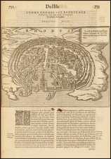
Gorgeous full color example of De Wit's map of Crete, with six insets showing Canea, Candia, Spina Longa, Retimo, Thine, and Suda. One of the most decorative maps of Crete, based on the map by Sébastian de Pontault Beaulieu, a French military engineer who had mapped the fortifications of many Mediterranean islands. His map of Crete was published in 1674, only 5 years after Crete had fallen to the Turks. after a 24-year seige. The seas around the island are filled with galleons & galleys representing this epic struggle. Above the map the title is on a banner held aloft by putti. The first state of the map, which was later re-issued by Covens & Mortier. A nice old color example of this most decorative map. ZACHARAKIS: 2393.
De Wit (1629 ca.-1706) was a mapmaker and mapseller who was born in Gouda but who worked and died in Amsterdam. He moved to the city in 1648, where he opened a printing operation under the name of The Three Crabs; later, he changed the name of his shop to The White Chart. From the 1660s onward, he published atlases with a variety of maps; he is best known for these atlases and his Dutch town maps. After Frederik’s death in 1706, his wife Maria ran the shop for four years before selling it. Their son, Franciscus, was a stockfish merchant and had no interest in the map shop. At the auction to liquidate the de Wit stock, most of the plates went to Pieter Mortier, whose firm eventually became Covens & Mortier, one of the biggest cartography houses of the eighteenth century.
![Carte De La Syrie [Shows Cyprus and the Holy Land!]](https://storage.googleapis.com/raremaps/img/small/61321.jpg)
![[ With Symbolism of 4 Religions ] Archipelagi Graeciae sive Maris Aegei cum Praecipuis Suis Insulis Geographica Descriptio](https://storage.googleapis.com/raremaps/img/small/95669.jpg)