|
||

|

|
|

|
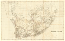
Striking, Detailed Chart of the Cape of Good Hope
Fine, scarcely-seen and separately-issued chart of the Cape of Good Hope by Johannes (II) van Keulen. This is one of the most detail-rich depictions of the Cape Colony of the early eighteenth-century.
The east-oriented chart stretches from Saldanha Bay to False Bay, with Table Bay nestled between them. Prominent islands, like Dassen and Robben Island, are included, as are rhumb lines, notes on the quality of the sea floor, sounding depths, and navigational obstructions.
Inland there is considerable detail. Bird’s-eye views of the shoreline are shown, with many coasts dominated by hills. Water sources are prominently marked, and labels indicate the kind and quality of the land and soil. Much of the land is shown as arable or good for grazing cows. Roads connecting settlements criss-cross the capes and promontories. These range from tiny company outposts to the houses and plantations of families (with the settler’s name) to small towns like Blauwenberg (Blaauwberg) to the main fort in Table Bay. Administrative districts are marked, like Stellenbosch, and there are also labels for large land grants and the Dutch-derived names for local peoples.
A double scale bar rests in the lower right corner, while a decorative cartouche fills the upper left. It shows a laconic Neptune gazing into the distance, while putti play with a map and dividers in the foreground. In the background is a stunning scene of Table Bay, which the sun smiles upon.
This chart is one of over two hundred separately-published charts released by the famous van Keulen firm. From the late-seventeenth century, they expanded the geographic coverage of their charts to include more of southern Africa and the route to the East Indies, in accordance with the expansion of the later editions of their famous Zee Fakkel. However, while never intended for a formal atlas, these separate charts could be added to atlases or bound into small regional chart bundles at the behest of an individual customer.
European settlement of the Cape of Good Hope
Bartolomeu Dias was the first European to reach the Cape in the early modern era. He landed there in 1488 and named the promontory the Cabo das Tormentas, or Cape of Storms. Joan II of Portugal renamed it as the Cape of Good Hope, a decidedly more optimistic name.
Saldanha Bay was initially called Table Bay after the Portuguese encountered it in 1503. In 1601, when nearby Table Bay was named the same thing, the name Saldanha was given to the first bay, after the Portuguese António de Saldanha who was a captain in the initial expedition. Saldanha also was the first European to anchor in the actual Table Bay and the first European to climb Table Mountain.
The Dutch settled the Cape in 1652 and established a camp near Table Bay. Today, this city is Cape Town. Initially intended as a resting point and refueling depot, and unlike other VOC holdings, the Cape Colony quickly became a settler community. Many retired VOC employees acquired land there, the forbears of the Boers. The colony was operated as a commandant until 1691, when it became a governorate of the Dutch East India Company (VOC). The Cape was hotly contested in the Napoleonic Wars, passing to Britain, then briefly controlled by the Batavian Republic, and then back the British in 1814.
Rarity
This chart is rarely seen on the market. We note a single example at auction in the past 30 years.
It is held in several institutional collection in the Netherlands, including in the National Archief, the Maritiem Museum Rotterdam, the Scheepvartmuseum (Amsterdam), and the Utrecht University Library.
A manuscript map covering the same area by Gerard van Keulen (ca. 1710) is held at the Biblioteca Angelica in Rome and is likely the base used to make this printed map.
The Van Keulens were a family of chartmakers and publishers. The firm, In de Gekroonde Lootsman (In the Crowned Pilot), was founded in 1678 by Johannes van Keulen (1654-1715). Van Keulen originally registered his business as a vendor of books and instruments (specifically cross-staffs). In 1680, however, he gained a privilege from the States of Holland and West Friesland for the publication of pilot guides and sea atlases.
In that year, van Keulen released his Zee-Atlas (Sea Atlas), which secured him a name in the competitive maritime publishing market. In 1681, he published the first volume of Nieuwe Lichtende Zee-Fakkel (New Shining Sea Torch). This would be the first of an eventual five volumes originally published between 1680 and 1684. A sixth volume was added in 1753. The Zee-Fakel won van Keulen lasting fame. The atlas had charts compiled by Claes Jansz Vooght and artwork from Jan Luyken. It proved immensely popular and was reprinted until 1783. There were translations in French, English, Spanish, and Italian.
The late-seventeenth century was an auspicious time to enter the maritime chart business. Previous industry leaders had either closed shop, died, or retired, leaving space for a new competitor. Van Keulen proceeded to buy up the stock and privileges of several maritime publishing firms; the most notable was the stock of Hendrik Doncker, acquired in 1693.
Johannes’ son, Gerard (1678-1726) took over the business upon his father’s death. Gerard was a skilled engraver and mathematician. His talents were noticed, as in 1706 he was named as Hydrographer to the Dutch East India Company (VOC).
In turn, Gerard’s son Johannes II (1704-1770) came to run the shop. He was also tied to the VOC, and his role as their chartmaker allowed his charts to be considered as quasi-official government documents. It is with access to formerly clandestine VOC geographic knowledge that Johannes the Younger was able to add a sixth volume to the Zee-Fakkel, which covered the East Indies. Johannes also continued to sell instruments, including the recently-invented Hadley’s Quadrant from 1744.
When Johannes II died in 1770, his widow ran the business in his stead, aided by her two sons, Cornelis Buys (1736-1778) and Gerard Hulst (1733-1801). Now a century old, the family business had extended to include an anchor factory. After Cornelis died in 1778, Gerard took on the management of the firm alone. He oversaw the introduction of sextants to their inventory and published the Dutch Nautical Almanac beginning in 1788. Annual editions appeared until 1885. Gerard also served as an original member of the Dutch Commission for Longitude at Sea from 1787.
Gerard’s widow ran the business for nine years after his death, when their son, Johannes Hulst, started to lead the firm in 1810. After his death in 1844, the firm passed out of family hands and into the control of Jacob Swert, a skilled cartographer who had worked for the business for two decades. He passed the work to his son, another Jacob, in 1866. By the mid-nineteenth century, the conversion from sail to steam had diminished the size of the market for charts. Fewer sailors needed fewer maps, charts, and instruments. In 1885, after 207 years in business, In de Gekroonde Lootsman closed its doors and auctioned its stock.
![[With Flags Added] The](https://storage.googleapis.com/raremaps/img/small/79510.jpg)
![[Simon's Town / False Bay, South Africa] Seamons Bay in the Bay of False](https://storage.googleapis.com/raremaps/img/small/87276.jpg)