|
||

|

|
|

|
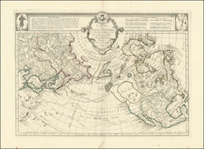
Landmark Map of North America by Coronelli with California as an Island
Fine example of Coronelli's cornerstone map of North America, one of the most influential maps of the continent published in the late seventeenth century.
The map is cartographically similar to Coronelli’s esteemed globe of 1688 and is richly embellished in his characteristic style. In the upper left is an elaborate title vignette featuring several gods who find themselves in the New World. They have sumptuous robes and voluptuous hair, but also a map, compass, ship, and other modern instruments. The title states not only the maker of the map, and his position as cosmographer of the Republic of Venice, but also lists the dedicatee, Felic Antonio Marsily, Archdeacon of the Cathedral of Bologna.
The other decorative element of the map is a large scale in the Atlantic Ocean, which is flanked by ribbon-clad branches. Additionally, a small text block in the Pacific Ocean is surrounded by a laurel and leaves. It explains how, even though some had thought California to be a peninsula, multiple Spanish voyages have shown it to be an island.
Several scenes are drawn into the geography of the continent itself, most depicting indigenous peoples acting as Europeans imagined they did—most likely a far cry from the realities of quotidian indigenous life and culture. For example, some naked men and women roast a human near Hudson’s Bay, while a massive alligator is munching people in what is today Louisiana. More informative are the sketches of indigenous people drying fish and burning wood.
In terms of geography, the map was one of the most updated representations of North America available at that time, even if some of that geography later proved chimerical. Much is still to be understood about the Arctic region, while the interior of the continent reflects the political divisions of the Spanish, French, and English empires.
Of particular note is the inclusion of Nuevo Suecia, wedged between Virginia and New York. New Sweden was a colony of the then-powerful Swedish empire from 1638 to 1655, when it was incorporated into the Dutch colony of New Netherland (which is not shown on this map). However, the settlers retained relative autonomy and, when this map was made, the area had been taken by the English. The colony was clearly well-enough known that Coronelli felt it important to include on his map.
The map is also noteworthy as the second earliest printed map to name Chicago.
Diego Dionisio de Peñalosa Briceño y Berdugo
Particularly in the west, Coronelli's map contributes a significant amount of new information. It draws heavily from the manuscript map by Diego Dionisio de Peñalosa Briceño y Berdugo, which included numerous previously unrecorded place names and divided the Rio Grande into the Rio Norte and the Rio Bravo in the south. The manuscript map was prepared by Peñalosa between 1671 and 1687, as part of his attempts to interest the French King Louis XIV in a military expedition against New Spain, which would reinstate Peñalosa as the governor or New Spain. The map records for the first time Peñalosa's subdivision of the Rio Grande into a northern and southern half, which Penalosa entitled Rio del Norte and Rio Bravo. Peñalosa also provided new information on settlements, forts, roads, and other important features in the landscape, perhaps most notably along the Rio del Norte, which south of Santa Fe has been provided with new information on the latest settlements their names.
Sieur de la Salle
Coronelli's depiction of the Great Lakes is the most advanced to date, drawing on information from the explorations of Louis Jolliet and Jacques Marquette. The other explorer mentioned several times on the map is René-Robert Cavelier, Sieur de La Salle.
La Salle was a Jesuit who had been granted land at the western End of Montreal. He learned from the local Mohawk peoples and became interested in riverine routes to the Gulf of Mexico. On his first expedition, of 1679-1682, La Salle and his men left Lake Ontario, went down the lower Niagara River, where they portaged over Niagara Falls. Then La Salle had a ship constructed, in which he sailed on Lake Erie and Lake Huron. The party then took to canoes in Lake Michigan and paddled down the Miami [St. Joseph] River; they eventually made it to Fort Crèvecoeur, marked on this map, which is modern Peoria, Illinois, before the expedition fell apart.
La Salle mounted another expedition, departing in 1682. He and his party left from Fort Crèvecoeur in canoes to sail down the Mississippi. While on the river, he named the basin La Louisiane; it is La Louisiana on this map. His men constructed a fort also marked on this map, Fort Prudhomme, which is the site of modern Memphis, Tennessee. Finally, they made it to the mouth of the Mississippi, and La Salle claimed the entirety of the river basin for France.
On later expeditions, La Salle attempted to found a French colony on the Gulf of Mexico and to locate the Mississippi again. On this map, the Mississippi basin reflects his discoveries and many notes mention his name. This map also depicts La Salle's misplacement of the mouth of the Mississippi, which he located some 600 miles to the west of its true location.
Danish Polar Exploration--Jens Munk
A reference in Hudson Bay identifies "Scoperto dagli Danesi" (Discovered by the Danes). This is a reference to the voyage of Danish-Norwegian explorer Jens Munk.
In 1619, Munk led an impressive journey commissioned by Danish King Christian IV, in search of the Northwest Passage. The goal was to secure a new and quicker route to India of behalf of the Danish Crown, and to colonize the route with intention of collecting taxes.
The expedition made it into Hudson Bay in the autumn of 1619 and set up camp for winter near the mouth of the Churchill River. When spring came, only Captain Munk and his cabin boy were still alive, the rest having succumbed to scurvy and starvation. Nearing death, Munk spent what he believed to be the last hours of his life in his cabin, writing his testimony of events in a shaky hand in the event that their bodies were one day found.
In the end, Munk survived and his letter still exists in the archives of the Royal Danish Library. He managed to rig a small yacht with the help of his cabin boy and together they crossed the Atlantic in early spring. Upon his return to Bergen (then Danish), Munk was imprisoned for wasting the King’s resources, but when King Christian heard of his unlikely return he immediately secured his release and brought him to Copenhagen. Munk’s records formed the basis for a royal commission investigating the possibilities of setting up a formal Danish colony on Hudson Bay. But due to the eruption of war across Europe, the notion was soon abandoned. It was only after the cessation of the Thirty-Year War (1618-48) that the British and French realized the value of this region and began to make their first claims.
Atlante Veneto
Coronelli's map of North America featured in his famous Atlante Veneto, published in Venice between 1690 and 1701. The atlas was Coronelli’s attempt to carry on the work of Blaeu and the Atlas Maior. The work was impressive in size (folio), detail, and length; it included many distinctive maps, with some, like this one, stretching over two sheets.
This is a significant map in the history of North American cartography, California as an island, and Italian mapmaking. It would be a foundational map in any collection of North America and would be an important addition to anyone interested in Coronelli, California, or early North American exploration.
The popular misconception of California as an island can be found on European maps from the sixteenth through the eighteenth centuries. From its first portrayal on a printed map by Diego Gutiérrez, in 1562, California was shown as part of North America by mapmakers, including Gerardus Mercator and Abraham Ortelius. In the 1620s, however, it began to appear as an island in several sources. While most of these show the equivalent of the modern state of California separated from the continent, others, like a manuscript chart by Joao Teixeira Albernaz I (ca. 1632) now in the collection of the National Library of Brasil shows the entire western half of North Americas as an island.
The myth of California as an island was most likely the result of the travel account of Sebastian Vizcaino, who had been sent north up the shore of California in 1602. A Carmelite friar, Fray Antonio de la Ascensión, accompanied him. Ascension described the land as an island and around 1620 sketched maps to that effect. Normally, this information would have been reviewed and locked in the Spanish repository, the Casa de la Contratación. However, the manuscript maps were intercepted in the Atlantic by the Dutch, who took them to Amsterdam where they began to circulate. Ascensión also published descriptions of the insular geography in Juan Torquemada’s Monarquia Indiana (1613) (with the island details curtailed somewhat) and in his own Relación breve of ca. 1620.
The first known maps to show California as an island were on the title pages of Antonio de Herrera’s Descripción de las Indias Occidentales (1622) and Jacob le Maire's Spieghel Der Australische Navigatie (1622). Two early examples of larger maps are those by Abraham Goos (1624) and another by Henry Briggs, which was included in Samuel Purchas’ Hakluytus Posthumus or Purchas his Pilgrimes (1625). In addition to Briggs and Goos, prominent practitioners like Jan Jansson and Nicolas Sanson adopted the new island and the practice became commonplace. John Speed’s map (1626-7), based on Briggs’ work, is well known for being one of the first to depict an insular California.
The island of California became a fixture on mid- and late-seventeenth century maps. The island suggested possible links to the Northwest Passage, with rivers in the North American interior supposedly connecting to the sea between California and the mainland. Furthermore, Francis Drake had landed in northern California on his circumnavigation (1577-80) and an insular California suggested that Spanish power in the area could be questioned.
Not everyone was convinced, however. Father Eusebio Kino, after extensive travels in what is now California, Arizona, and northern Mexico concluded that the island was actually a peninsula and published a map refuting the claim (Paris, 1705). Another skeptic was Guillaume De L’Isle. In 1700, De L’Isle discussed “whether California is an Island or a part of the continent” with J. D. Cassini; the letter was published in 1715. After reviewing all the literature available to him in Paris, De L’Isle concluded that the evidence supporting an insular California was not trustworthy. He also cited more recent explorations by the Jesuits (including Kino) that disproved the island theory. Later, in his map of 1722 (Carte d’Amerique dressee pour l’usage du Roy), De L’Isle would abandon the island theory entirely.
Despite Kino’s and De L’Isle’s work, California as an island remained common on maps until the mid-eighteenth century. De L’Isle’s son-in-law, Philippe Buache, for example, remained an adherent of the island depiction for some time. Another believer was Herman Moll, who reported that California was unequivocally an island, for he had had sailors in his offices that claimed to have circumnavigated it. In the face of such skepticism, the King of Spain, Ferdinand VII, had to issue a decree in 1747 proclaiming California to be a peninsula connected to North America; the geographic chimera, no matter how appealing, was not to be suffered any longer, although a few final maps were printed with the lingering island.
Vincenzo Maria Coronelli (1650-1718) was one of the most influential Italian mapmakers and was known especially for his globes and atlases. The son of a tailor, Vincenzo was apprenticed to a xylographer (a wood block engraver) at a young age. At fifteen he became a novice in a Franciscan monastery. At sixteen he published his first book, the first of 140 publications he would write in his lifetime. The order recognized his intellectual ability and saw him educated in Venice and Rome. He earned a doctorate in theology, but also studied astronomy. By the late 1670s, he was working on geography and was commissioned to create a set of globes for the Duke of Parma. These globes were five feet in diameter. The Parma globes led to Coronelli being named theologian to the Duke and receiving a bigger commission, this one from Louis XIV of France. Coronelli moved to Paris for two years to construct the King’s huge globes, which are 12.5 feet in diameter and weigh 2 tons.
The globes for the French King led to a craze for Coronelli’s work and he traveled Europe making globes for the ultra-elite. By 1705, he had returned to Venice. There, he founded the first geographical society, the Accademia Cosmografica degli Argonauti and was named Cosmographer of the Republic of Venice. He died in 1718.