


|
||

|

|
|

|
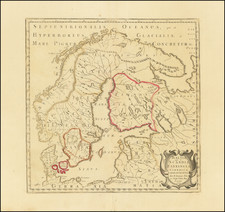
Decorative example of the scarce early Dutch Sea Chart of Barents Sea and contiguous parts of Norway, Finland and Russia, published by Hendrick Doncker in 1658.
The chart covers the coastline of Greenland discovered by Gaal Hamkes in 1654, perhaps the earliest printed map to report this discovery.
The coverage stretches from northern Norway across the North Cape to Nova Zemla, with a finely detailed image of the coastal areas of Russia, Finland, Norway and Svalbard, as well as some known shoals. There is also a inset map of Arkhangelsk, along with two sailing ships, compass roses and rhumb lines.
This is among the earliest Dutch sea charts to cover this region and the first of several sea charts of the region by Doncker.
Hendrik Doncker was a prominent bookseller in Amsterdam best known for his sea charts and nautical atlases. He issued his own original charts, which he updated frequently, and also worked with colleagues like Pieter Goos, for example to produce the pilot guide, De Zeespeigel. He died in 1699, after fifty years in business. His plates then passed to Johannes van Keulen.
![(Second World War - NVKD SMERSH) Übersicht der Verkehrsverbindungen mit Sonntagsrückfahrkarte von Berlin. Gültig während des Winterfahrplans 1938/39 [Overview of the Transport Links with Sunday return ticket from Berlin. Valid During the Winter Timetable 1938/39]](https://storage.googleapis.com/raremaps/img/small/69563.jpg)