|
||

|

|
|

|
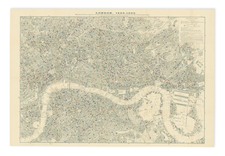
A Historical Retrospective Published in 1808, Based on the Unobtainable 22-Sheet 1676 Ogilby and Morgan Wall Map of London.
Fine original antique map of The Strand, in London, in the region around Temple Station and Temple Gardens. The map is based on the 1676 Ogilby and Morgan A Large and Accurate Map of the City of London. . ., an immense twenty-two sheet wall map of the city.
Visible on the map is the area where many of the Inns of Court of London are located, including Inner and Middle Temple. In addition to the two inns not visible on the map, Lincoln's Inn and Grey's Inn, these organizations count as their members all qualified barristers (lawyers) in England and Wales.
The map includes a marvelous amount of detail, showing individual plots, garden layouts, and more. In all, a wonderful map of this unusually quiet and peaceful part of London.
![[ London ] Londinum Feracis: Ang. Met.](https://storage.googleapis.com/raremaps/img/small/74642.jpg)
![[London]](https://storage.googleapis.com/raremaps/img/small/72497.jpg)