This item has been sold, but you can enter your email address to be notified if another example becomes available.


|
||

|

|
|

|
Stock# 80924
Description
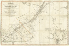
Rare American Published Sea Chart
Detailed sea chart of Maritime and Eastern Canada and New England, published in New York by Blunt.
The map extends inland to Quebec and south to Buzzard's Bay and New Bedford. Includes a large inset of Cape Cod and an large inset of the Gut of Canso, Chedabuctou Bay, etc.
The inset of Cape Cod Harbour notes that is is based upon the US Surveys undertaken by Major J.D. Graham of the US Topographical Engineers in 1833, 1834 and 1835, with details on tides, soundings, etc.
A good example of this classic working sea chart.
Rarity
The chart is quite rare. We locate no examples offered for sale or at auction in RBH or AMPR.
OCLC locates an 1851 edition at the BnF and an 1852 edition at McMaster University.
Condition Description
Blue backed and laid on linen. Soiling, with minor loss at lower left corner. some dampstaining and soiling.
![[Halifax and Fredericton] Barraks und Markthaus in Frederikton New Brunswick | Ansicht von Halifax, von Darmouth Cove](https://storage.googleapis.com/raremaps/img/small/86080.jpg)
![[Quebec] Profil de la Ville de Quebec et de ses environs attaquee par Les Anglois en L'annee 1691](https://storage.googleapis.com/raremaps/img/small/90028.jpg)