|
||

|

|
|

|
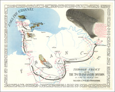
Interesting original vintage map of the 3rd Panzer Division's role in the Fall of France, showing the route taken from Viersen over the border into Belgium, and southwards to Grenoble. This map was issued after the completion of the campaign as a celebratory map for those who had fought in the campaign. The 3rd Panzer Division was an instrumental part of the Blitzkrieg tactic that led to the rapid fall of Allied forces in Western Europe.
The map shows the route taken by the Division over the border into the Netherlands and Belgium. The division initially went north to try to stop the evacuation of allied troops that had been encircled, but subsequently turned south at the end of May to continue in the invasion of France. This second stage of the campaign saw a southward march past Paris, although the German tank division encountered more resistance than it had initially anticipated.
The map lists a series of waypoints describing the progress of the invasion during the months of May and June 1940. A Panzer tank is shown in the lower-left corner of the map. Cities, rivers, and pre-war geopolitical borders (with Alsace-Lorraine carved out) are shown on the map. Battles are indicated with crossed swords.
The 3rd Panzer Division was a German Tank division that had been established in 1935 and partook in all of the major and horrific campaigns executed by Nazi Germany during the Second World War. The division served in Spain, Poland, France, and the Soviet Union, and it eventually surrendered to western Allied troops.
![(Second World War - Postwar Reconstruction) [Archive of Materials Related to American Reconstruction Efforts in Bavaria]](https://storage.googleapis.com/raremaps/img/small/88055.jpg)
![(Second World War - Sudetenland) Wer Braucht Sicherheit im Südosten? [Who Needs Security in the Southeast?]](https://storage.googleapis.com/raremaps/img/small/98159.jpg)
![(World War II) [Iwo Jima Aerial Reconnaissance Photograph, March 8, 1945]](https://storage.googleapis.com/raremaps/img/small/83776.jpg)