


|
||

|

|
|

|
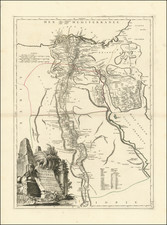
Rare 19th century map shows the course of the Nile River in southern Egypt and northern Sudan. The map shows the most up-to-date mapping of the interior of the African continent, and was compiled by James Wyld from a number of governmental and private sources.
The map was published at the start of formal British rule in Egypt and Sudan, when British troops had recently conquered Egypt following the growth of anti-imperialist sentiment. This 1882 conquest allowed the British to formally station themselves as head of the country, having followed a period in which they were forced to share power with Egyptian, French, and Ottoman entities.
Control of the Nile was vital for British interests in the region, however, in 1882 they were still weakly represented above the cataracts. The Mahdist State had seen the fall of Egyptian independence, and that same year they conducted a surprise attack against a British-led Egyptian force. They continued this revolt until the fall of British-held Khartoum (shown on the map), and British control of the Sudan was stymied for another decade and a half.
The map includes topographical information, cataracts, place names, tribal names, caravan routes, railways, ruins, and telegraph lines. The map shows the split between the White and Blue Niles in the southernmost part of the map. This level of organization would have been critical for staff-level planning of military organizations.
The map includes dedication to "General Lord Wolseley, G.C.B." Wolseley was the British Commander tasked with suppressing the Urabi Revolt in 1882. After returning to his duties as adjutant-general, in September 1884 he led an unsuccessful expedition to rescue General Gordon and the besieged garrison at Khartoum.
Rarity
The map is apparently very rare. We were unable to locate another example offered for sale in a dealer catalog or at auction.
OCLC locates several editions between 1883 and 1896, all exceedingly rare.
James Wyld Sr. (1790-1836) was a British cartographer and one of Europe’s leading mapmakers. He made many contributions to cartography, including the introduction of lithography into map printing in 1812.
William Faden, another celebrated cartographer, passed down his mapmaking business to Wyld in 1823. The quality and quantity of Faden’s maps, combined with Wyld’s considerable skill, brought Wyld great prestige.
Wyld was named geographer to Kings George IV and William IV, as well as HRH the Duke of York. In 1825, he was elected an Associate of the Institution of Civil Engineers. He was one of the founding members of the Royal Geographical Society in 1830. Also in 1830, his son, James Wyld Jr., took over his publishing house. Wyld Sr. died of overwork on October 14, 1836.
James Wyld Jr. (1812-87) was a renowned cartographer in his own right and he successfully carried on his father’s business. He gained the title of Geographer to the Queen and H.R.H. Prince Albert. Punch (1850) described him in humorous cartographic terms, “If Mr. Wyld’s brain should be ever discovered (we will be bound he has a Map of it inside his hat), we should like to have a peep at it, for we have a suspicion that the two hemispheres must be printed, varnished, and glazed, exactly like a pair of globes.”
![[English Language Edition!] Natoliae Quae Olim Asia Minor Nova Descriptio [with] Aegypti Recentior Descriptio [with] Carthageinis Celeberrimi Sinus Typus [shows Cyprus]](https://storage.googleapis.com/raremaps/img/small/78508.jpg)