|
||

|

|
|

|
Stock# 80615
Description
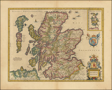
Valk and Schenk's antique engraved map of Angus in eastern Scotland.
The map lists dozens of small towns and shows mountains, rivers, glens, firths, lochs, and many other features.
This map represents a later state of a map of the same name first published by Jan Jansson sometime around 1646. Jansson published a series of maps of the British regions, which were based on the most accurate sources at the time.
Condition Description
Original hand-color in outline. Cartouches with later hand-color.
![[ Scotland ] Scotiae Tabula](https://storage.googleapis.com/raremaps/img/small/77829.jpg)
![[Scotland] Scotiae Tabula](https://storage.googleapis.com/raremaps/img/small/35612.jpg)
![[ United Kingdom ] Tabula Prima Europae](https://storage.googleapis.com/raremaps/img/small/78537.jpg)