


|
||

|

|
|

|
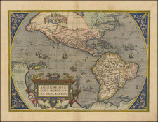
A Separately-Published Cornerstone of Abraham Ortelius Collecting -- The Final State of Abraham Ortelius' Map of the Americas, One of the Most Iconic Maps of the Western Hemisphere
Abraham Ortelius's map of America is without doubt one of the most recognized and influential maps of the Americas from the sixteenth century. It had a profound influence on contemporary cartography.
The present example is the rare, separately published final state of the map, released shortly after the discovery of the Le Maire Strait, and significantly post-dating the last regularly published edition of Oretlius's atlas in 1612. There is no text on the verso.
Ortelius' map of the Americas was issued utilizing three different copper plates between 1570 and 1612. This final state utilized the still-surviving third copper plate, and was issued separately after 1617, several decades after Ortelius's death.
The map, which shows both North and South America, featured in Abraham Ortelius' Theatrum Orbis Terrarum, the first modern atlas of the world. Ortelius’ Americae Sive Novi Orbis Nova Descriptio is without a doubt one of the most recognized and influential maps of the Americas from the sixteenth century and it had a profound influence on contemporary cartography.
The map went through three separate plates over the course of its printed life, creating three editions. Additionally, there are several states of the first and third editions. This is the rarest of the states, the final state of the third edition.
North and South America stretch across this single hemisphere map. To the north, North America somewhat resembles the continent we know today, except the area near Alaska is undefined and the northwest bulges westward. South America is a squat landmass; early editions have an extension in the southwest that would disappear in later editions of the map.
The title is decorated with the strapwork decorations characteristic of the maps in Ortelius’ atlas. In the ocean, a sea monster lurks. In the Pacific, ships stream through the water, their sails filled with imaginary winds.
The Straits of Magellan separate South America from a large southern continent that extends all the way to New Guinea. Tierra del Fuego, named by Magellan because he saw so many small fires burning there, is part of this continent. The name "Novae Guinea", or New Guinea, was coined by Spanish explorer Íñigo Ortíz de Retes in 1545, and it refers to his opinion that the appearance of the native peoples resembled the natives of the Guinea region of Africa.
Two place names in the northwest of North America are particularly interesting. Anian derives from Ania, a Chinese province on a large gulf mentioned in Marco Polo’s travels (ch. 5, book 3). The gulf Polo described was actually the Gulf of Tonkin, but the province’s description was transposed from Vietnam to the northwest coast of North America. The first map to do was Giacomo Gastaldi’s world map of 1562, followed by Zaltieri and Mercator in 1567. The Strait then became shorthand for a passage to China, i.e. a Northwest Passage. It appeared on maps until the mid-eighteenth century.
Quivira refers to the Seven Cities of Gold sought by the Spanish explorer Francisco Vasquez de Coronado in 1541. In 1539, Coronado wandered over what today is Arizona and New Mexico, eventually heading to what is now Kansas to find the supposedly rich city of Quivira. Although he never found the cities or the gold, the name stuck on maps of southwest North America, wandering from east to west.
Ortelius' ability to locate and draw upon both Spanish and Portuguese sources is apparent throughout the map, and is quite remarkable, given the manner in which each nation guarded its cartographic information. Both nations kept their geographic knowledge locked in a single institution, with all cartographic knowledge maintained on a single master map. Copies of the master map were closely monitored, and pilots could be punished for not returning their charts; however, no vault is impenetrable and geographic secrets leaked out, including to Ortelius in Antwerp.
Ortelius' atlas and the states of Americae Sive/Novi Orbis
The influence of this and other Ortelius maps stems from the popularity and dominance of his atlas in the European market. In 1570, Ortelius published the first modern atlas; that is, a set of uniform maps with supporting text gathered in book form. Previously, there were other bound map collections, specifically, the Italian Lafreri atlases, but these were sets of maps--they were not necessarily uniform and were bound together on demand.
Theatrum Orbis Terrarum, Ortelius's atlas, outperformed competing atlases from other cartographic luminaries like the Mercator family. Between 1570 and 1612, 31 editions of the atlas were published in seven languages. This map, in its first edition, appeared in the very first 1570 atlas.
The plate was replaced twice, for a total of three plates and creating three editions. The second plate was engraved in 1579; the large ship in the Pacific reverses direction and the cartouche has different figures. In 1587, the third plate was made, this time to reduce the bulge on South America’s west coast and to add details in the islands of the Pacific.
There were also several states of each edition, except the second, of which no extra states are known by Van den Broecke. For the first edition, for example, in 1573, the mislabeled Azores, first called the Canariae insule, were corrected to Las Acores. The third state of this edition had the longitude number 230 erased and was most likely made in 1575.
Major changes in the final (post-1617) state
This state uses the final plate, first used in 1587. Most of the changes to the map appear around the Strait of Magellan. These include:
- Terra del Fuego now appears as an island of sorts, surrounded on sides by water
- The entrance to Magellan Strait now includes the name Fretum le Maire
- The Names Maruritius and C. Hoor (Cape Horn) appear on the new "island" of Terra del Fuego
- Staatenlant is shown as a promontory across the Fretum Le Maire from Terra del Fuego
- The coast of the Southern continent has been significantly changed, removing a number of place names, including C. del Fuego, P. Grande, P. del Nort, Sierra de menadas, Campana de Roldan and C.mal conoschiudo
- An island north of the former C.mal consosciudo has been removed and the river modified
- I. Barnevelt has been added south of Terra del Fuego
- The date of 1587 has been removed at the bottom right.
There are other changes on the map of note (which have previously not been observed by published scholars):
- B. de Todos Santos (Brazil) appears for the first time, replacing "R. real"
- R. Prenambuco has been replaced by "Fernambuco" with the symbol of a settlement shown.
Previous scholarship on this map seems to have overlooked the two Brazilian changes (see Schilder's notes below). These changes may be important clues in dating the final revisions to the map. Archival research has shown that Moretus intended to republish the Theatrum in 1618 but failed to do so. The Le Maire changes support dating the plate changes to circa 1618. However, the Brazilian changes mean that a publication date of circa 1630 is far more likely; Recife and Bahia Todo Santos were the major focus of Dutch colonization efforts in that year, while they were not particularly important to the Low Countries before that. The other possibility is that the map was revised once in circa 1618, and again in circa 1630, though examples of the final state are too rare to make comparisons.
Scholarly Note on Ortelius's Maps After 1612
As noted by Gunter Schilder, Monumenta Cartographica Neerlandica, Volume III, page 256:
. . . for a long time it was supposed that the history of this atlas of the world ended with the Spanish edition of 1612, and that the copperplates were not used any more. Already in Volume II of my Monumenta Cartographica Neerlandica I have referred to the copperplates for the maps of Ortelius, which were re-published, complete with alterations, by Theodoor Galle and his son Joannes.
From archive material we know that in 1618 Balthasar Moretus made preparations for a reissue of the Theatrum: he paid rather high sums to engravers Ferdinand Arsenius and Arnold Floris van Langren for the adaptation of the copperplates. The mathematician Godefridus Vendelinus was to write an explanatory text. For reasons unknown this project was shelved. However, the recent discovery of a complete copy of the atlas provides that, in spite of this, an atlas of the world appeared in the forties [1640s], in which the plates were printed on the old Spanish text sheets of 1612. Both on the map of the world by Ortelius and on the one of America the representation of the big, unknown Southland ('Terra Avstralis nondvm cognita', 'Terra Avstralis, sive Magellanica hactenvs incognita', respectively) in the region of South America is interrupted and completed with the discoveries made during the voyage of Le Maire. Both maps include the following names: 'Fretum le Maire', 'Mauritius', 'staten lant', 'C. Hoorn' and 'I. Barnevelt'. On both map the islands of the Pacific, discovered by Le Maire, as well as the new shape of the northern coast of New Guinea were overlooked.
Importance of the third edition
The present example is a third edition, which was printed on a separate copper plate from earlier editions. This third edition incorporated several highly important new discoveries and firsts.
- The first appearance of Chesapeake Bay on a map: The inclusion of a large inlet in the east seaboard of North America, labeled with the Indian name "Wingandekoa", reflects the earliest unsuccessful attempts by the English to colonize the area.
- The first appearance of the Solomon Islands on a map: While the islands were first discovered by Álvaro de Mendaña de Neira in 1568, they did not appear on a printed map until Ortelius's third Americas map.
- New toponyms have been added in California: Ortelius adds the name "California". He also adds "Cab. Mendocino", which was discovered by Juan Rodriquez Cabrillo in 1542. "R. de los estrechos" is added.
The dating of the final state of the map has ranged from after 1617 to 1641. Given that that the only changes to the map are near the Le Maire Strait and Brazil, an early date, to ca. 1630, seems most likely.
Cartographic sources
The primary source for the map is Gerard Mercator's 1569 wall map of the world. According to Brandmair, Ortelius's revisions for the third plate were probably spurred on by the publication of Giovanni Mazza's map of the Americas, published in Venice by Rascicotti in 1583.
Rarity
This late state of the map is exceedingly rare. Burden located seven examples of the map in private and institutional collections.
This is the first example of this state of the map to appear on the market in approximately fifteen years (Cartographica Neerlandica, New Acquisitions, April 2006, priced at approximately $24,450 USD).
Ortelius's Theatrum Orbis Terrarum (or "Theater of the World") is widely considered to be the first modern atlas, meaning that this was the first published set of uniform maps with supporting text gathered in book form. Previous bound map collections exist, for example the Italian Lafreri atlases, but these were sets of maps selected and bound together on demand. The Theatrum, in contrast, was the best available summary of sixteenth-century cartographic knowledge, covering much of the exploration of the world in the century following the discovery of America.
The atlas was first published in 1570 in Antwerp. Ortelius’ atlas outperformed later competing atlases from other cartographic luminaries like the De Jode and the Mercator families. The broad appeal of the work is demonstrated by the array of languages in which the atlas appeared: in addition to Latin, the atlas was published with text in Dutch, French, German, Italian, Spanish, and English. Between 1570 and 1612, at least 31 editions of the atlas were published in seven languages. The editions grew over time, with the first edition having 70 maps on 53 sheets, and the 1612 edition having 167.
At the time of its publication, the Theatrum was the most expensive book ever produced. Ortelius created all the maps personally, hand drawing the rough sketches. Those drawings were then interpreted into prints by his engravers Frans Hogenberg, Ambrosius Arsenius, and Ferdinand Arsenius.
After Ortelius's death in 1598, the copper plates for his atlas passed to his heirs. They, in turn, sold the collection to Jan Baptist Vrients (1522-1612) in 1601. Vrients added new maps and published the atlas until his own death in 1612. Vrients's widow then sold the plates to the Moretus brothers, who were the successors of Christoffel Plantin. Recent research has unearthed examples of the atlas with maps dated to 1640.
Abraham Ortelius is perhaps the best known and most frequently collected of all sixteenth-century mapmakers. Ortelius started his career as a map colorist. In 1547 he entered the Antwerp guild of St Luke as afsetter van Karten. His early career was as a business man, and most of his journeys before 1560, were for commercial purposes. In 1560, while traveling with Gerard Mercator to Trier, Lorraine, and Poitiers, he seems to have been attracted, largely by Mercator’s influence, towards a career as a scientific geographer. From that point forward, he devoted himself to the compilation of his Theatrum Orbis Terrarum (Theatre of the World), which would become the first modern atlas.
In 1564 he completed his “mappemonde", an eight-sheet map of the world. The only extant copy of this great map is in the library of the University of Basel. Ortelius also published a map of Egypt in 1565, a plan of Brittenburg Castle on the coast of the Netherlands, and a map of Asia, prior to 1570.
On May 20, 1570, Ortelius’ Theatrum Orbis Terrarum first appeared in an edition of 70 maps. By the time of his death in 1598, a total of 25 editions were published including editions in Latin, Italian, German, French, and Dutch. Later editions would also be issued in Spanish and English by Ortelius’ successors, Vrients and Plantin, the former adding a number of maps to the atlas, the final edition of which was issued in 1612. Most of the maps in Ortelius' Theatrum were drawn from the works of a number of other mapmakers from around the world; a list of 87 authors is given by Ortelius himself
In 1573, Ortelius published seventeen supplementary maps under the title of Additamentum Theatri Orbis Terrarum. In 1575 he was appointed geographer to the king of Spain, Philip II, on the recommendation of Arias Montanus, who vouched for his orthodoxy (his family, as early as 1535, had fallen under suspicion of Protestantism). In 1578 he laid the basis of a critical treatment of ancient geography with his Synonymia geographica (issued by the Plantin press at Antwerp and republished as Thesaurus geographicus in 1596). In 1584 he issued his Nomenclator Ptolemaicus, a Parergon (a series of maps illustrating ancient history, sacred and secular). Late in life, he also aided Welser in his edition of the Peutinger Table (1598).
![[Fruit Crate Label Advertising Map] Panama Brand (North America & Panama Canal)](https://storage.googleapis.com/raremaps/img/small/48860.jpg)
![Amerique Septentrionale divisee en Ses Principales parties . . . . 1674 [Rare First State]](https://storage.googleapis.com/raremaps/img/small/99317.jpg)
