


|
||

|

|
|

|
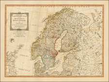
Fantastic original antique map of Scandinavia and Iceland. This highly decorative map was first published in London by Emanuel Bowen in the mid-18th century for his A Complete System of Geography.
The map is highly detailed, showing Denmark, Sweden, Norway, and Finland, as well as part of Russia. A highly decorative cartouche shows a polar bear hunt. Three coats of arms and a compass rose appear.
An inset in the upper part of the map entitled A Map of Spitzbergen or Greenland, Iceland, and some part of Groenland shows the Northern Ocean, with Svalbard, Iceland, and the eastern coast of Greenland included. The map refers to Spitzbergen as "Greenland," which is how English whalers referred to the islands in the 17th and 18th centuries.
Emanuel Bowen (1694?-1767) was a British engraver and print seller. He was most well-known for his atlases and county maps. Although he died in poverty, he was widely acknowledged for his expertise and was appointed as mapmaker to both George II of England and Louis XV of France. His business was carried on by his son, Thomas Bowen. He also trained many apprentices, two of whom became prominent mapmakers, Thomas Kitchin and Thomas Jeffreys.
![(Northern Scandinavia) Carte des Couronnes du Nord Dediée Au très Puissant et très Invincible Prince Charles XII, Roy de Suède, des Gots et des Vandales, Grand Duc de Finlande, &c. &c. &c. [Map of the Northern Crowns Dedicated to the Very Powerful and Invincible Prince Charles XII, King of Sweden, of the Goths and Vandals, Grand Duke of Finland, etc. etc. etc.]](https://storage.googleapis.com/raremaps/img/small/92675.jpg)
![[ Norway and Sweden ] Septentrionalium Regionum Suetiae Gothiae Norvegia Daniae](https://storage.googleapis.com/raremaps/img/small/67558.jpg)